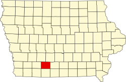
Union County, Iowa
 The Union County Courthouse in Creston |
|
| administration | |
|---|---|
| US state : | Iowa |
| Administrative headquarters : | Creston |
| Address of the administrative headquarters: |
County Courthouse 300 North Pine Street Creston, IA 50801-2252 |
| Foundation : | January 15, 1851 |
| Made up from: | Pottawattamie County |
| Area code : | 001 641 |
| Demographics | |
| Residents : | 12,534 (2010) |
| Population density : | 11.4 inhabitants / km 2 |
| geography | |
| Total area : | 1103 km² |
| Water surface : | 4 km² |
| map | |
| Website : www.unioncountyiowa.org | |
The Union County is a county in the US -amerikanischen State Iowa . In 2010 , the county had 12,534 residents and a population density of 11.4 people per square kilometer. By 2013 the population increased to 12,583. The county seat is Creston .
geography
The county is located in central southwest Iowa and covers an area of 1,103 square kilometers, of which four square kilometers are water. It borders on the following neighboring counties:
| Adair County Madison County | ||
| Adams County |

|
Clarke County |
| Taylor County | Ringgold County | Decatur County |
history
| Population development | |||
|---|---|---|---|
| Census | Residents | ± in% | |
| 1860 | 2012 | - | |
| 1870 | 5986 | 197.5% | |
| 1880 | 14,080 | 135.2% | |
| 1890 | 16,900 | 20% | |
| 1900 | 19,928 | 17.9% | |
| 1910 | 16,616 | -16.6% | |
| 1920 | 17,268 | 3.9% | |
| 1930 | 17,435 | 1 % | |
| 1940 | 16,280 | -6.6% | |
| 1950 | 15,651 | -3.9% | |
| 1960 | 13,712 | -12.4% | |
| 1970 | 13,557 | -1.1% | |
| 1980 | 13,858 | 2.2% | |
| 1990 | 12,750 | -8th % | |
| 2000 | 12,309 | -3.5% | |
| 2010 | 12,534 | 1.8% | |
| 2013 estimate | 12,583 | 0.4% | |
| Before 1900 1900–1990 2000 2010–2013 | |||
Union County was formed on January 15, 1851. At the time the county was formed, the conflict between the northern and southern states was smoldering. Since the general opinion tended towards the north, i.e. the Union, the term was adopted as a name.
population

As of the 2010 census , Union County had 12,534 people in 5,326 households. The population density was 11.4 inhabitants per square kilometer. Statistically, 2.28 people lived in each of the 5326 households.
The racial the population was composed of 96.9 percent white, 0.7 percent African American, 0.3 percent Native American, 0.5 percent Asian and other ethnic groups; 1.0 percent were descended from two or more races. Regardless of ethnicity, 1.8 percent of the population was Hispanic or Latino of any race.
23.4 percent of the population were under 18 years old, 58.5 percent were between 18 and 64 and 18.1 percent were 65 years or older. 51.3 percent of the population was female.
The median income for a household was 40,879 USD . The per capita income was $ 20,435. 17.8 percent of the population lived below the poverty line.
Localities
Citys and Census-designated places (CDP) :
| place | Residents 2010 |
Type |
|---|---|---|
| Creston | 7834 | City |
| Afton | 845 | City |
| Lorimor | 360 | City |
| Cromwell | 107 | City |
| Arispe | 100 | City |
| Shannon City 1 | 71 | City |
| Kent | 61 | CDP |
| Thayer | 59 | City |
1 - partially in Ringgold County
Other unincorporated communities not recorded separately from the census :
structure
Union County is divided into twelve townships :
|
|
The city of Creston does not belong to any township.
See also
Individual evidence
- ↑ GNIS-ID: 465276. Retrieved on February 22, 2011 (English).
- ↑ a b c U.S. Census Bureau, State & County QuickFacts - Union County, IA. Retrieved February 22, 2015
- ↑ a b National Association of Counties.Retrieved February 22, 2015
- ^ US Census Bureau - Census of Population and Housing.Retrieved March 15, 2011
- ^ Extract from Census.gov.Retrieved February 16, 2011
- ↑ Extract from the National Register of Historic Places - No. 73000739.Retrieved February 21, 2011
- ↑ American Fact Finder. Retrieved February 22, 2015
- ↑ 2010 US Census Iowa Township and Other Subdivision Population. Retrieved July 23, 2019 .
Web links
Coordinates: 41 ° 2 ′ N , 94 ° 14 ′ W
