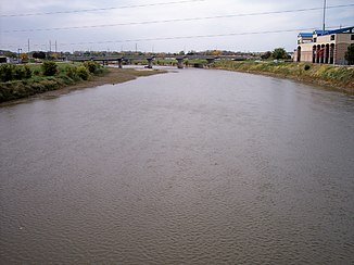
Raccoon River
| Raccoon River | ||
|
The Raccoon River catchment area |
||
| Data | ||
| Water code | US : 460494 | |
| location | Iowa (USA) | |
| River system | Mississippi River | |
| Drain over | Des Moines River → Mississippi River → Gulf of Mexico | |
| Beginning | The confluence of the North Raccoon Rivers and South Raccoon Rivers at Van Meter , Dallas County , Iowa 41 ° 32 ′ 38 ″ N , 93 ° 58 ′ 0 ″ W |
|
| Source height | 239 m | |
| muzzle | Des Moines River, Des Moines , Iowa Coordinates: 41 ° 34 ′ 46 " N , 93 ° 36 ′ 44" W 41 ° 34 ′ 46 " N , 93 ° 36 ′ 44" W. |
|
| Mouth height | 232 m | |
| Height difference | 7 m | |
| Bottom slope | 0.14 ‰ | |
| length | 49.6 km | |
| Big cities | Des Moines | |
| Medium-sized cities | West Des Moines | |
|
The Raccoon River shortly from its mouth at Des Moines |
||
The Raccoon River is a 49.6 km long river in the center of the US -amerikanischen state of Iowa . Its course begins at the confluence of the North Raccoon River with the South Raccoon River at Van Meter in Dallas County and ends with the confluence with the Des Moines River in the metropolitan area of Iowa's capital Des Moines .
The source rivers, which include the Middle Raccoon River , are all longer than the river itself:
- The North Raccoon River is the longest headwaters at 315 km. It rises north of Marathon in Buena Vista County in northwest Iowa on 42.9016 ° N , 94.9747 ° W .
- The Middle Raccoon River is the second longest headwaters at 148 km. It rises southwest of Breda in Carroll County in west-central Iowa on 42.1564 ° N , 95.0644 ° W . It flows into the much shorter South Raccoon River near Redfield in Dallas County ( 41.5722 ° N , 94.195 ° W ).
- The South Raccoon River is the shortest source river at 116 km. It rises in the Viola Township of Audubon County in west-central Iowa on 41.8247 ° N , 94.7928 ° W . After the tributary of the longer Middle Raccoon River , it is about 35 km to the confluence with the North Raccoon River .
Individual evidence
- ^ A b Geographic Names Information System of the United States Geological Survey - Raccoon River.Retrieved November 27, 2014
- ↑ Geographic Names Information System of the United States Geological Survey - North Raccoon River.Retrieved November 27, 2014
- ^ Geographic Names Information System of the United States Geological Survey - Middle Raccoon River.Retrieved November 27, 2014
- ↑ Geographic Names Information System of the United States Geological Survey - South Raccoon River.Retrieved November 27, 2014

