Irtyash
| Irtyash | ||
|---|---|---|

|
||
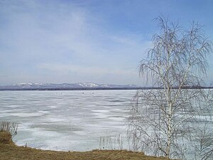
| The Irtjasch in winter 2006 | ||
| Geographical location | Russia ( Chelyabinsk Oblast ) | |
| Drain | Tetscha → Isset → Tobol → Irtysh → Ob | |
| Places on the shore | Osjorsk , Kasli | |
| Data | ||
| Coordinates | 55 ° 49 ′ N , 60 ° 44 ′ E | |
|
|
||
| Altitude above sea level | 227 m | |
| surface | 53.5 km² | |
| length | 14 km | |
| width | 5 km | |
| Maximum depth | 16 m | |
The Irtjasch ( Russian Иртя́ш ; from Bashkir Иртәш ) is a lake in the Chelyabinsk Oblast ( Russia ) on the eastern edge of the Urals .
It is 53.5 km² and a maximum of 16 meters deep. The Irtjasch lies at an altitude of 227 m . It extends for about 14 kilometers in a north-south direction with a width of up to 5 kilometers.
The lake is fed by several small rivers, such as the Kyschtym from a south-westerly direction and the Mauk , which flows from the lake Großer Kasli ( Bolschije Kasli ) to the north . At Osjorsk , the Tetscha , a right tributary of the Isset in the Ob river system, leaves the Irtjasch in the southeast .
There are several islands in the lake, of which the island Svetljak on the west side is the largest. To the south of it, the Moskin peninsula juts far into the lake.
On the north bank of the lake is the city of Kasli , on the south bank of Osjorsk, the formerly secret city of Chelyabinsk-40 and Chelyabinsk-65 . The Mayak nuclear facility , in connection with which the city was built, is located downstream in the catchment area of the Tetscha, so that the Irtjasch itself was not or less radioactively contaminated during the various nuclear incidents.
On the Irtjasch can therefore u. a. Regional sailing competitions are held, such as a stage of the Chelyabinsk Oblast Match Race Championship 2007.
Individual evidence
- ↑ a b Article Irtjasch in the Great Soviet Encyclopedia (BSE) , 3rd edition 1969–1978 (Russian)
- ↑ Irtjasch in the State Water Directory of the Russian Federation (Russian)
- ↑ Soviet topographic map 1: 200,000 N-41-1 (1990)
