Ixtapaluca
| Ixtapaluca | ||
|---|---|---|
|
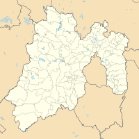
Coordinates: 19 ° 18 ′ N , 98 ° 53 ′ W Ixtapaluca on the map of Mexico
|
||
| Basic data | ||
| Country | Mexico | |
| State | México (state) | |
| Municipio | Municipio Ixtapaluca | |
| City foundation | 1531 | |
| Residents | 270,521 (2010) | |
| - in the metropolitan area | 429.033 | |
| Detailed data | ||
| surface | 80.3 km 2 | |
| Population density | 3,369 inhabitants / km 2 | |
| height | 2260 m | |
| Time zone | UTC −6 | |
| Ixtapaluca - aerial view | ||
Ixtapaluca is one of Mexico City's many satellite cities . Since 1820 it has been the capital of the municipality of the same name in the state of México .
Location + residents
The city of Ixtapaluca, with a population of around 270,000, is located on the gentle slopes of the Cerro de Montezuma about 32 km southeast of the capital of Mexico at an altitude of about 2260 m above sea level. d. M. The city is on the CF150 to Puebla .
history
As the ruins of Acozac show, the area around Ixtapaluca was already settled before the arrival of the Spaniards under Hernán Cortés . The parish of Ixtapaluca was founded in 1531 and a few years later (1543) passed into the hands of Juan de Cuéllar , who - according to ancient Indian custom - demanded tributes from the residents every 80 days in the form of in kind. Since the middle of the 16th century, the missionary work of the Indian population was the responsibility of the Franciscan and Dominicans .
In 1820 Ixtapaluca became the capital of the newly founded municipality. With the explosive growth of Mexico City in the second half of the 20th century, Ixtapaluca - together with the neighboring cities Chalco and Neza - developed into a huge satellite city or slum area.
Attractions
The ruins of Acozac , dating from the Aztec period (approx. 1430–1521), lie in the north of the city. On the way there you pass the El Nido bird park .
Individual evidence
Web links
- Ixtapaluca - City website (Spanish)

