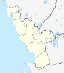
Jälluntofta
| Jälluntofta | ||||
|
||||
| State : | Sweden | |||
| Province (län): | Hallands Lan | |||
| Historical Province (landskap): | Halland | |||
| Municipality : | Hylte | |||
| Coordinates : | 57 ° 3 ' N , 13 ° 32' E | |||
| Height : | 195 m ö.h. | |||
Jälluntofta is a place in the municipality of Hylte in the Swedish province of Hallands Lan .
location
The place Jälluntofta is located on the banks of the lake Jällunden , about 24 kilometers east of the main town of the municipality Hylte, Hyltebruk . After Skeppshult is around 17 kilometers, according Ulvsryd about 15 kilometers.
history
Until 2010, Jälluntofta was the seat of a parish ( församling , formerly socken ), which then became part of Unnaryds församling .
The name of the parish Jälluntofta was mentioned in a document from the Diocese of Linköping as early as the 13th century . The size of the parish, which is divided by the lake Jällunden, covers about 4000 hectares. In the seventies of the 19th century around 500 people lived in this area, today only about 50, so that the Jällunden area with less than 2 inhabitants per square kilometer is one of the most sparsely populated in southern Sweden.
Attractions
- Chalanderska Museum, is an intact cabinet maker from the 19th century. The exhibition is particularly concerned with inlays for altarpieces and furniture that were made here by the former owner Johannes Chalander (1844–1931).
- Jälluntofta kyrka, the church in the village was built in 1861. Remains of a pulpit from 1690 and a sandstone baptismal font from the original church, which was built at the end of the 13th century, are still preserved.
- Jällunden, the 870 hectare lake with its many small islands and bathing areas.
- Jälluntoftaleden hiking trail, a 12-kilometer-long signposted hiking trail with six rest areas and some shelters, for which the hiker needs about 3.5 hours.
- Skyttepaviljongen, the rifle pavilion built in 1904 by members of the rifle club, now belongs to the local history club .
- Spånghultet, a small farm in the moor, which could only be reached via a boardwalk (Spång, Swedish for "footbridge"). Today the farm belongs to the Heimatverein.
Individual evidence
- ↑ a b c Hylte kommun, January 27th 2012 - Välkommen till Jälluntofta , (Swedish, English and German) (PDF; 112 kB)


