
Jambirdji
Location of Jambirdji in Niger |

Jambirdji (also: Djambirgi , Djambirji , Jambirji , Jambriji , Jan Birji , Janbirji ) is a village in the Gouchi rural community in Niger .
The village, run by a traditional chief ( chef traditionnel ), is located about 16 kilometers southwest of Gouchi, the capital of the rural community of the same name, which belongs to the Dungass department in the Zinder region. Another large village in the vicinity of Jambirdji is Wacha in the west , which is also around 16 kilometers away . The regional capital Zinder is about 62 kilometers to the north-west.
The place name means "blood-red earth".
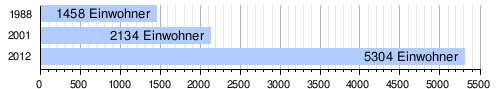
At the 2012 census, Jambirdji had 5,304 inhabitants who lived in 702 households. At the 2001 census, the population was 2,134 in 382 households, and at the 1988 census, the population was 1,458 in 367 households.
There is a simple health center in Jambirdji without its own laboratory or maternity ward.
- Wildlife at Jambirdji village

Migratory locust
Oedaleus senegalensis
Migratory locust
Oedaleus senegalensis
Short probe cricket
Scintharista notabilis


Individual evidence
- ↑ a b National Repertoire des Localités (ReNaLoc). (RAR) Institut National de la Statistique de la République du Niger, July 2014, p. 572 , accessed on August 7, 2015 (French).
- ^ Zbigniew R. Dmochowski: An introduction to Nigerian traditional architecture . Vol. 1: Northern Nigeria. Ethnographica, London 1990, ISBN 0-905788-26-5 , pp. 6 .
- ^ Répertoire National des Communes (RENACOM). (RAR file) (No longer available online.) Institut National de la Statistique, archived from the original on January 9, 2017 ; Retrieved November 8, 2010 (French). Info: The archive link was inserted automatically and has not yet been checked. Please check the original and archive link according to the instructions and then remove this notice.
- ↑ Recensement Général de la Population 1988: Répertoire National des Villages du Niger . Bureau Central de Recensement, Ministère du Plan, République du Niger, Niamey March 1991, p. 398 ( ceped.org [PDF; accessed January 31, 2018]). www.ceped.org ( Memento of the original dated January 31, 2018 in the Internet Archive ) Info: The archive link was inserted automatically and has not yet been checked. Please check the original and archive link according to the instructions and then remove this notice.
- ^ Niger DSS. In: Systems Nationale d'Information Sanitaire (SNIS). Ministère de la Santé Publique, République du Niger, accessed on October 14, 2018 (French).
Coordinates: 13 ° 24 ' N , 9 ° 27' E