Belaya (Anadyr)
|
Belaja Белая, Юрумкувеем (Jurumkuwejem) |
||
|
|
||
| Data | ||
| Water code | RU : 19050000212119000115277 | |
| location | Chukchi Autonomous Okrug ( Russia ) | |
| River system | Anadyr | |
| Drain over | Anadyr → Bering Sea | |
| source |
Anadyr Plateau 67 ° 39 ′ 8 ″ N , 172 ° 3 ′ 35 ″ E |
|
| muzzle | at Ust-Belaja in the Anadyr coordinates: 65 ° 30 ′ 46 ″ N , 173 ° 16 ′ 21 ″ E 65 ° 30 ′ 46 ″ N , 173 ° 16 ′ 21 ″ E
|
|
| length | 396 km (total length with tributary Bolshoi Pykarwaam 487 km) | |
| Catchment area | 44,700 km² | |
| Left tributaries | Bolshoi Pykarwaam , Tschaawaam , Bolshaya Ossinowaja | |
| Right tributaries | Enmywaam | |
| Communities | Ust-Belaya | |
|
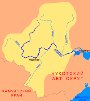
Location of the Belaja ( Белая ) in the catchment area of the Anadyr |
||
The Belaja ( Russian Бе́лая , "The White") is a left tributary of the Anadyr in eastern Siberia , the upper reaches of which is the Jurumkuwejem ( Юрумкувеем ).
The river has its source on the Anadyr plateau . From there it initially flows in an easterly direction, later mainly in a southerly direction. He takes the left-side tributaries Bolshoi Pykarwaam , Tschaawaam and Bolshaya Ossinowaja on. At river kilometer 111 the Enmywaam , which drains the Elgygytgyn crater lake , meets the Jurumkuwejem from the right. This confluence marks the beginning of the lower reaches called Belaja . The Belaja flows into the Anadyr at Ust-Belaja . The river has a total length of 396 km. Together with the tributary Bolshoi Pykarwaam, the maximum length of the river system is 487 km. The Belaja has a catchment area of 44,700 km². The river freezes in late October / early November and is ice-free again from early June. The river forms a spawning area for salmon fish .
