
Kälbertshausen
|
Kälbertshausen
municipality Hüffenhardt
|
|
|---|---|
 |
|
| Height : | 313 m |
| Area : | 4.2 km² |
| Residents : | 533 (December 31, 2008) |
| Population density : | 127 inhabitants / km² |
| Incorporation : | 1st January 1975 |
| Postal code : | 74928 |
| Area code : | 06268 |
Kälbertshausen is a village in the Neckar-Odenwald district , which has been incorporated into Hüffenhardt since 1975 .
geography
Kälbertshausen is located at the transition from the Kraichgau hill country to the Kleiner Odenwald about three kilometers north of Hüffenhardt. To the east of Kälbertshausen, the wooded Kailbachtal slopes down to the Neckar , around three kilometers away .
history


Kälbertshausen can be traced back to a Roman villa rustica , a courtyard to supply the Roman soldiers stationed on the Limes . After the Romans withdrew in the 3rd century, an Alemannic settlement developed, which is the origin of today's place. The village is first mentioned in a document in 976 , the oldest spelling dates from 1150 and is Husen , 1325 is from Kelwartzhusen , 1440 from Kelwershusen and 1483 from Kelwertshausen . The place name possibly refers to the profession of charcoal burner , which was traditionally practiced in the wooded area, but possibly also gives a reference to a "Kelwart", which could have founded the modern place.
At the Grafenweg north of Kälbertshausen there was an undated castle, Kälbertshausen Castle .
The village was under the sovereignty of the diocese of Worms . A church existed from the Middle Ages. In the late Middle Ages, Engelhard von Weinsberg sold one third each to the lords of Helmstatt , the lords of Gemmingen- Guttenberg and Gemmingen-Babstadt (later Hornberg). The purely rural town developed as a street village, the sloping village street of which forked uphill in the northeast and downhill in the southwest and did not form any other significant cross streets.
During the Thirty Years' War the place was practically depopulated. In 1648 four families were still counted. In the 18th century, 31 families were counted again in 1743, and immigrants from Switzerland and Tyrol also settled here. During the French Wars, however, Kälbertshausen was hit hard again between 1792 and 1799. The names of Schanzwiesen and Bollwerk still bear witness to the fighting .
After the French Revolutionary Wars , Kälbertshausen came to the newly created Grand Duchy of Baden . In 1816 a famine broke out that lasted the following year. In 1847 and 1851 there are again reports of famines. A storm on August 31, 1860 devastated the place and the surrounding forests and fields. The church tower was destroyed and almost all the roofs in the village were covered. The forest damage should be visible for over 30 years. The ongoing hardship caused a large wave of emigration in the second half of the 19th century, which was followed by another wave after the First World War .
In the period around the First World War, the water supply of the town was problematic because the old village well for reasons of hygiene were not allowed to be used and the south of the village located Bergbrunnen dried up in the summer. The water was therefore mostly brought in by cart from the nearby fenced fountain before a water supply with the water from the fenced fountain and the holy fountain near Mörtelstein was set up in 1923 , which served until the place was connected to the network of the Mühlbach water supply group in 1976.
In 1939 there were 284 inhabitants, at the end of 1945 there were 342.
The place has been dominated by agriculture until the present day. In the course of the community reform, Kälbertshausen was incorporated into Hüffenhardt on January 1, 1975.
coat of arms
The blazon reads: A black calf's head in the visor over a shield base in gold divided by blue and silver.
Buildings
- The origins of the local church date from the Middle Ages and have a Gothic rib vault. The nave was built in 1726. There is a war memorial in front of the church.
- The rectory is next to the church.
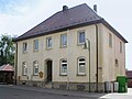
- The town hall is a simpler, more recent building.
- Several ornate half-timbered houses have been preserved in the village along the local road.

church

Rectory
town hall

Hist. Half-timbered house


Sons and daughters of the place
- Alfred Kaufmann (1868–1946), evangelical theologian and orientalist
Individual evidence
- ↑ Eckhard Hoffmann: The "Fenced Well". A small source with a great past . In: Badische Heimat 2004. Heimatkalender for Neckartal, Odenwald, Bauland and Kraichgau , Heidelberg 2004, pp. 211–216.
- ↑ Communications from the Württ. And Bad. State Statistical Office No. 2: Results of the population census on December 31, 1945 in North Baden
- ^ Federal Statistical Office (ed.): Historical municipality directory for the Federal Republic of Germany. Name, border and key number changes in municipalities, counties and administrative districts from May 27, 1970 to December 31, 1982 . W. Kohlhammer, Stuttgart / Mainz 1983, ISBN 3-17-003263-1 , p. 485 .