
King's Gate (Kaliningrad)

The Königstor in Kaliningrad , formerly Königsberg , is one of six former city gates and part of the fortification facilities in Königsberg , which were built in Königsberg in the 19th century. It was in the Neue Sorge district at the end of Koenigsstrasse. The previous gate built from palisades was called Gumbinner Gate . In 1820 several goods lying in front of the gate are listed and Devau and Kalthof are listed as belonging to the vicinity of the gate.
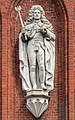
The design came from Friedrich August Stüler . The west facade was decorated with three sandstone statues by the sculptor Wilhelm Stürmer : At a height of nine meters, the Bohemian King Ottokar II , to whom Königsberg owes his name, stands, in the middle, King Friedrich I crowned himself for the first time in the Königsberg Castle Church in 1701 King in Prussia. On the right, Albrecht von Brandenburg-Ansbach watches over the city. He was the founder of the Duchy of Prussia and the University of Albertina . The coats of arms of the Samland and Natangens are attached above the figures . Among the figures are the coats of arms of Bohemia , Prussia and Brandenburg . The coats of arms were executed in lava painting.
The gate was damaged in World War II. The Soviet soldiers had cut off the heads of the figures. At the city's 750th anniversary in July 2005, the King's Gate was used as the official symbol of the city's jubilee. After the decision for this symbol had been made, the restoration of the building was carried out in a temporal act of violence. A few months before the official start of the anniversary celebrations, the King's Gate was in a desolate state. The 19th century monument, built in the style of the old religious architecture, was restored within a very short time. The figures, mutilated in 1945, also returned completely to the facade.
Image gallery
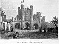
The royal gate in the 19th century

The King's Gate in the Empire

The King's Gate in the Empire
The Königstor out of town

German officers captured at the Königstor of Koenigsberg, April 12, 1945

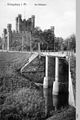
The Königstor before the restoration

The Königstor before the restoration

Statue of Ottokar II.
Statue of Friedrich I.
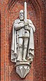
Statue of Albrecht of Prussia

Coat of arms of Bohemia

Coat of arms of Prussia

Brandenburg coat of arms


literature
- Robert Albinus: Königsberg Lexicon. City and surroundings . Flechsig, Würzburg 2002, ISBN 3-88189-441-1 .
- Richard Armstedt: history of the royal. Capital and residence city of Königsberg in Prussia. Hobbing & Büchle, Stuttgart 1899 ( German land and life in single descriptions . 2, city stories), (reprint: Melchior-Verlag, Wolfenbüttel 2006, ISBN 3-939102-70-9 ( historical library )).
- Fritz Gause : The history of the city of Königsberg in Prussia. 3 volumes. 2nd / 3rd supplemented edition. Böhlau, Cologne et al. 1996, ISBN 3-412-08896-X .
- Johann Friedrich Goldbeck (Ed.): Complete topography of the Kingdom of Prussia. Part 1: Topography of East Prussia. Kanter, Königsberg et al. 1785 (reprint: Association for family research in East and West Prussia, Hamburg 1990).
- Jürgen Manthey : Königsberg - history of a world citizenship republic . Hanser , Munich 2005, ISBN 3-446-20619-1 .
- Frey Herr von Schroetter : Map of East Prussia together with Prussian Litthauen and West Prussia together with Netzedistrict. Sheet 6: Labiau, Königsberg, Wehlau. Simon Schropp, Berlin 1802 (Facsimile: Hans Mortensen (Hrsg.): Historisch-Geographischer Atlas des Preußenlandes. Part 6. Franz Steiner Verlag, Wiesbaden 1978, ISBN 3-515-02671-1 ), (approx. 1: 160 000) .
- Gunnar Strunz: Discover Königsberg. Between Memel and fresh lagoon . Trescher, Berlin 2006, ISBN 3-89794-071-X .
- Samuel Gottlieb Wald : Topographical overview of the administrative district of the Royal Prussian Government in Königsberg in Prussia. Degen, Königsberg 1820 (reprint: self-published by the Association for Family Research in East and West Prussia eV, Hamburg 1979 ( special publications of the Association for Family Research in East and West Prussia eV 43, ISSN 0505-2734 )).
Coordinates: 54 ° 42 ′ 49.2 ″ N , 20 ° 32 ′ 9 ″ E