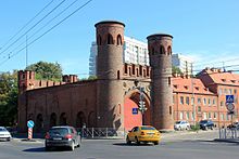
Sackheim Gate
The Sackheimer Tor ( Russian Закхаймские ворота , Sakchaimskije worota) in the Russian city of Kaliningrad is a city gate of the former inner Königsberg fortification ring . It is located at the intersection of Moskowski propekt and uliza Litowski wal. It is named after the Königsberg district of Sackheim . A future use of the gate as a museum for measuring instruments is planned.
history
The gate on Sackheimer Strasse once gave its crew the opportunity to monitor the arterial road to Insterburg . It was mentioned as early as 1785 together with the two copper hammers in front of the gate and the “Sackheim Pest House”. In 1812, after the signing of the Tauroggen Convention , Ludwig Yorck von Wartenburg rode through the Sackheimer Tor in Königsberg to urge the East Prussian estates to revolt against French rule. In 1820 the shooting house, some mills, "goods and jugs" (inns) are listed in the vicinity of the gate.
Today's gate was built in the middle of the 19th century and was probably the simplest of all the city gates of the fortification facilities in Königsberg . The passage was in the middle of the gate, with a round tower covering each side. Relief medallions by Ludwig Yorck von Wartenburg and Friedrich Wilhelm Bülow von Dennewitz were attached above on both sides . On the field side the towers were provided with loopholes, on the city side with windows.
The casemates , where earlier the gate guards were housed were, after razing removed early 20th century the inner defense ring. There was a moat with a drawbridge on the field side . Until 2006 the gate was used as a warehouse. The relief medallions and the Prussian black eagle attached to the field side have been lost.
architecture
The neo-Gothic gate is decorated with ornaments and sandstone flowers.
literature
- Robert Albinus: Königsberg Lexicon. City and surroundings. Special edition. Flechsig, Würzburg 2002, ISBN 3-88189-441-1 .
- Richard Armstedt : history of the royal. Capital and residence city of Königsberg in Prussia. Hobbing & Büchle, Stuttgart 1899 ( German land and life in single descriptions . 2, city stories), (reprint: Melchior-Verlag, Wolfenbüttel 2006, ISBN 3-939102-70-9 ( historical library )).
- Fritz Gause : The history of the city of Königsberg in Prussia. 3 volumes. 2nd / 3rd supplemented edition. Böhlau, Cologne et al. 1996, ISBN 3-412-08896-X .
- Johann Friedrich Goldbeck (Ed.): Complete topography of the Kingdom of Prussia. Part 1: Topography of East Prussia. Kanter, Königsberg et al. 1785 (reprint: Association for family research in East and West Prussia, Hamburg 1990).
- Frey Herr von Schroetter : Map of East Prussia together with Prussian Litthauen and West Prussia together with Netzedistrict. Sheet 6: Labiau, Königsberg, Wehlau. Simon Schropp, Berlin 1796–1802 (facsimile: Hans Mortensen (Ed.): Historisch-Geographischer Atlas des Preußenlandes. Part 6. Franz Steiner Verlag, Wiesbaden 1978, ISBN 3-515-02671-1 ), (approx. 1: 160 000).
- Gunnar Strunz: Discover Königsberg. On the way between Memel and Haff. Trescher, Berlin 2006, ISBN 3-89794-071-X ( Trescher travel series ).
- Samuel Gottlieb Wald : Topographical overview of the administrative district of the Royal Prussian Government in Königsberg in Prussia. Degen, Königsberg 1820 (reprint: self-published by the Association for Family Research in East and West Prussia eV, Hamburg 1979 ( special publications of the Association for Family Research in East and West Prussia eV 43, ISSN 0505-2734 )).
Web links
Coordinates: 54 ° 43 ' N , 20 ° 32' E


