Kabataş
| Kabataş | ||||
|
||||
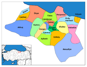
 Location Kabatas in Ordu District |
||||
| Basic data | ||||
|---|---|---|---|---|
| Province (il) : | Ordu | |||
| Coordinates : | 40 ° 45 ′ N , 37 ° 27 ′ E | |||
| Residents : | 5,734 (2012) | |||
| Telephone code : | (+90) 452 | |||
| Postal code : | 52520 | |||
| License plate : | 52 | |||
| Structure and administration | ||||
| Mayor : | Yakup Yılmaz ( AKP ) | |||
| Website: | ||||
| Kabataş County | ||||
| Residents : | 10,923 (2014) | |||
| Surface: | 74 km² | |||
| Population density : | 148 inhabitants per km² | |||
| Kaymakam : | Engin Avcı | |||
| Website (Kaymakam): | ||||
Kabataş is a Turkish city and district in Ordu Province .
The city is located about 45 km southwest of the provincial capital Ordu on the descent of the Canik mountain range ( Pontic Mountains ) to the Black Sea at an altitude of 701 m above sea level. NN .
The city of Kabatas has over 5000 inhabitants and offers the infrastructure for trade and supply to the district of the same name. There are also schools and a grammar school there. The district is predominantly agricultural and feeds almost 11,000 people. The focus is on corn, potatoes, nuts, honey and cattle breeding. The climate is continental, with influences from the Black Sea climate and great differences between the summer and winter months when snow falls.
The place was first mentioned in a document in 1380. In 1971 it was elevated to a town.
Individual evidence
- ^ Turkish Institute for Statistics, 2012 ( Memento of February 20, 2013 on WebCite ), accessed October 17, 2015
- ^ Turkish Institute for Statistics, 2014 ( Memento February 10, 2015 on WebCite ), accessed October 17, 2015


