
Kalkwand (Stubai Alps)
| Limestone wall | ||
|---|---|---|
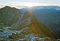
 Limestone wall from the south. Left the Innsbrucker hut |
||
| height | 2564 m above sea level A. | |
| location | Northeast of the Pinnisjoch | |
| Mountains | Stubai Alps | |
| Dominance | 0.98 km → Ilmspitze | |
| Notch height | 130 m ↓ notch to the Ilmspitze | |
| Coordinates | 47 ° 2 '48 " N , 11 ° 19' 9" E | |
|
||
| Normal way | From the Innsbrucker Hütte on the marked trail | |

The limestone wall is 2564 m above sea level. A. high mountain in the Stubai Alps in Tyrol . The multi-pointed ridge structure of the limestone wall lies northeast of the Pinnisjoch ( 2370 m ), a transition between Pinnis and Gschnitztal . The summit is the first elevation in the Serleskamm , which runs northeast from the Pinnisjoch . The limestone wall is considered the summit of the Innsbrucker Hütte . Therefore, the landlord of this hut erected the cross that is still present today on the summit of the limestone wall.
Climbs
The normal route leads from the Innsbrucker Hütte over a marked trail, initially through the northwest flank. In a notch you change to the southwest side of the mountain, which is initially traversed slightly uphill, and finally you reach the summit from the south. From the saddle, the summit can also be climbed directly in a short climb ( UIAA II ) over the southwest ridge. The ascent from the Innsbrucker Hütte takes about an hour.
The mountain is often climbed in the course of the ascent of the Illmspitz via ferrata.
literature
- Walter Klier : Alpine Club Guide Stubai Alps. Bergverlag Rudolf Rother , Munich 2006, ISBN 3-7633-1271-4
gallery

Summit cross with a view of the Innsbrucker Hut
Limestone wall from the west, from the ascent to the Habicht

