Kammertenberg
| Kammertenberg | ||
|---|---|---|
| height | 285.3 m above sea level NN | |
| location | Baden-Wuerttemberg , Germany | |
| Coordinates | 48 ° 56 '16 " N , 8 ° 53' 8" E | |
|
|
||
| Type | Table Mountain | |
| rock | Upper Muschelkalk, lower Keuper | |
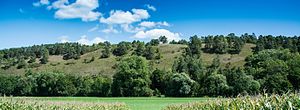
The Kammertenberg is a by Talmäandrierung Excised elevation in the valley of the Neckar influent Enz between the areas of Muehlacker Mulhouse and Lomersheim . It extends with a length of about 1.5 kilometers from north to south and appears from the valley perspective from Lomersheim as a table mountain with a steep slope exposed to the west and sparse, Mediterranean-looking vegetation. Geologically, it consists of layers of the upper shell limestone and the lower Keuper with little layer falling to the north.
Its highest point reaches 285.3 meters above sea level. Its upper edge is about 60 meters above the river bed of the Enz . In addition to an abandoned quarry in the Upper Muschelkalk, a deep sinkhole hole suddenly appeared in 1955 , presumably as a result of relief expansion joints and salt or gypsum leaching , which has a diameter of about 1.5 meters on the surface and which steams from the depths on frosty days. Up until the first half of the 20th century there was a quarry in the lower Keuper above the northern third of the western slope, which is partly used for agricultural purposes. It was possibly also used for the extraction of Letten coal. Until the 1930s it had become the residence of a Roma clan, which is why the spring on Käsberg-Straße was called the Gypsy spring . In the 1940s, the Lomersheim garbage dump was set up there and operated until the mid-1970s. Afterwards, a composting test area was set up on the covered dump and a public chopping and composting area is still operated on the now elevated level.
On the steep western slope, the vegetation is in a succession stage with pines and open heather areas due to poor soil formation, edaphic drought and because of the flaming that was common up until the 1950s . a. the pasque flower (Pulsatilla vulgaris) and a few orchids grow. The area has been designated as a Kammertenberg nature reserve with a size of 17.5 hectares since 2012 .

