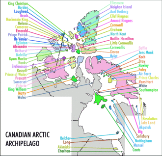
Canadian Arctic Archipelago
| Canadian Arctic Archipelago | ||
|---|---|---|
| Waters | Arctic Ocean | |
| Geographical location | 75 ° 0 ′ N , 90 ° 0 ′ W | |
|
|
||
| Number of islands | 36563 | |
| Main island |
Baffin Island , Victoria Island , Ellesmere Island |
|
| Total land area | 1,424,500 km² | |
| Residents | 17,000 (2011) | |
The Canadian Arctic Archipelago is the northern archipelago of Canada . It is located in the north of Canada and borders Greenland . The archipelago, located in the Arctic Ocean , has a population of almost 17,000 - mainly Inuit . Around 11,000 of them live on the largest island, Baffin Island , and there again for the most part (6,700 inhabitants) in Iqaluit .
history
The first proven exploration of the island world by Europeans took place with the voyages of the English navigator Martin Frobisher in the late 1570s. Thereafter, the island world belonged to British North America and only came to the Franklin District in 1880 , which is part of the Northwest Territories of Canada. Within Canada, the island world today mainly belongs to the territory of Nunavut and to a lesser extent to the northwest territories.
From the Canadian side, Hans Island is also included in the archipelago. However, their national affiliation is disputed between Canada and Denmark , which represents the autonomous Greenland in foreign policy.
geography
The archipelago includes more than 36,000 mostly small and tiny islands. Only 94 of the islands are defined as larger islands with an area greater than 130 km². The largest islands are Baffin Island , Ellesmere Island , Victoria Island and Banks Island . The Queen Elizabeth Islands comprise more than 2,100 individual islands and have a total area of 419,061 km². This makes it the largest group of islands within the archipelago. The Queen Elizabeth Islands are not the only group of islands within the entire archipelago. Other island groups in the archipelago are for example the Royal Geographical Society Islands , the Astronomical Society Islands or the Hecla and Fury Islands .
The total land area of all the islands in the archipelago is around 1,424,500 km².
| Surname | Territory * | Area km² |
Ranking list | Population (2001) |
|
|---|---|---|---|---|---|
| world | Canada | ||||
| Baffin Island |
|
507451 | 5 | 1 | 9563 |
| Victoria Island |
|
217291 | 9 | 2 | 1707 |
| Ellesmere Island |
|
196236 | 10 | 3 | 168 |
| Banks Island |
|
70028 | 24 | 5 | 114 |
| Devon Island |
|
55247 | 27 | 6th | 0 |
| Axel Heiberg Island |
|
43178 | 32 | 7th | 0 |
| Melville Island |
|
42149 | 33 | 8th | 0 |
| Southampton Island |
|
41214 | 34 | 9 | 721 |
| Prince of Wales Island |
|
33339 | 40 | 10 | 0 |
| Somerset Island |
|
24786 | 46 | 12 | 0 |
| Bathurst Island |
|
16042 | 54 | 13 | 0 |
| Prince Patrick Island |
|
15848 | 55 | 14th | 0 |
| King William Island |
|
13111 | 61 | 15th | 960 |
| Ellef Ringnes Island |
|
11295 | 69 | 16 | 0 |
| Bylot Island |
|
11067 | 72 | 17th | 0 |
| Prince Charles Island |
|
9521 | 78 | 19th | 0 |
* NT = Northwest Territories , NU = Nunavut
See also
literature
- Hans Frebold : Geology of the Arctic . 1st edition. tape 1 . Gebr. Borntraeger, Stuttgart 2004, ISBN 978-3-443-01053-9 .
Web links
- Arctic Archipelago ( English, French ) In: The Canadian Encyclopedia . Retrieved August 21, 2016.


