Prince Patrick Island
| Prince Patrick Island | |
|---|---|
| Prince Patrick Island satellite image | |
| Waters | Arctic Ocean |
| Archipelago | Queen Elizabeth Islands |
| Geographical location | 76 ° 38 ′ N , 119 ° 51 ′ W |
| length | 240 km |
| width | 80 km |
| surface | 15,848 km² |
| Highest elevation | (unnamed) 279 m |
| Residents | uninhabited |
| main place | (Mold Bay) |
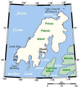
| Map of the island | |
The Prince Patrick Iceland is the westernmost island of the Queen Elizabeth Islands and is located in the Northwest Territories of Canada . The uninhabited island is 240 km long, 30–80 km wide and only 150–200 m high. It has an area of 15,848 km² and thus ranks 14th among the largest islands in Canada and 55th among the largest islands in the world.
It is separated from Melville Island in the southeast by Kellett Strait and Fitzwilliam Strait , and from Banks Island in the south by McClure Strait .
It was discovered and researched independently in 1853 by George Frederick Mecham (1828-1858) and Francis Leopold McClintock . It was named after Prince Arthur William Patrick , Governor General of Canada from 1911 to 1916 .
Mold Bay
Mold Bay is a Canadian weather station (manned until 1995, now automatic) on the island and is located at 76 ° 15 ′ north latitude and 119 ° 30 ′ west longitude .
Farquharson, et al. published a scientific article in 2019 on the decline in permafrost soil at three measuring stations, including the Mould Bay weather station, in the Canadian high Arctic between 2003 and 2017. According to the authors, the soil at the weather station sagged by around 90 centimeters during the period examined. The reason for this development seems to be the thawing of the permafrost; The permafrost table is shifting to ever greater depths due to the frequent, above-average warm summers, as the summer thawing soil has a limited heat buffer capacity and thus insulates the permafrost soil poorly against rising temperatures.
Web links
Individual evidence
- ↑ The Atlas of Canada - Queen Elizabeth Islands ( Memento from January 22, 2013 in the Internet Archive ) (English)
- ^ A b Louise M. Farquharson, Vladimir E. Romanovsky, William L. Cable, Donald A. Walker, Steven Kokelj, Dimitry Nicolsk: Climate change drives widespread and rapid thermokarst development in very cold permafrost in the Canadian High Arctic . In: Geophysical Research Letters . June 2019, doi : 10.1029 / 2019GL082187 .


