Kangerluk
| Kangerluk (fjord) | ||
|---|---|---|
| Diskofjord Kangerdluk | ||
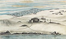
| Jakob Danielsen's birthplace (1925) | ||
| Commune | Qeqertalik municipality | |
| District | Qeqertarsuaq | |
| Geographical location | 69 ° 29 '4 " N , 53 ° 56' 56" W | |
|
|
||
| Residents | 11 (January 1, 2020) |
|
| Time zone | UTC-3 | |
Kangerluk [ kaˈŋɜɬːuk ] (according to the old spelling Kangerdluk ) is a Greenlandic settlement in the district of Qeqertarsuaq in the municipality of Qeqertalik .
location
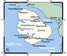
Kangerluk is, along with the capital Qeqertarsuaq , 31 km south-southeast , the only still inhabited settlement in the Qeqertarsuaq district on Disko Island . The place is located on the southern tip of a peninsula covered by Mount Qilertaa between the fjords of Avannarput in the north and Kangerluarsuk . The eponymous fjord Kangerluk runs south, past the island of Qeqertaq .
history
Before the colonial era
The fjord may have been visited by Dutch whalers around 1700. The name of Cape Qallunaaq ("white man") with graves indicates that Europeans were buried there. Around 1760 the fjord was inhabited by numerous Greenlanders, but around 15 years later the area was only used as a summer place.
The Udsted in Qivittut
In March 1792, inspector Børge Johan Schultz visited the fjord in order to find suitable places for setting up a yarn trap. In the autumn of 1792 an earth house was built in Qivittut (→ map) in which a few Danish sailors and some Greenlandic boys were quartered. “Qivittoq” is the Greenlandic term for a person who retires to the mountains alone. According to legend, a widow accused of witchcraft once settled here with her children, which made them all qivittut . In January 1793, the men arrived in Qeqertarsuaq, exhausted from hunger. The hunting yield was too small to survive. In the following winters the attempt was repeated and it went a little better. On September 29, 1796, the crew's boat sank, two Danes and six Greenlanders died and all materials and merchandise were lost. Thereupon qivittut was given up.
In 1802 the Danish sailor Johan Drenghan and his Greenlandic family settled in Naanngisat (→ map) and caught seals, capelin and salmon. Several other families soon moved in and Johan Drenghan started running a shop. In 1805 Naanngisat had seven inhabitants and eleven lived in Maligiaq (→ map) . In 1808 19 people lived in the fjord. In 1809 Johan Drenghan moved to Qivittut before he died in 1816. In 1821 only eleven people lived in the fjord.
In 1830 orders were made to relocate some of the residents of Qeqertarsuaq to the fjord as the lodge was overpopulated. A Danish carpenter was employed as Udsteds administrator, but in 1832 all residents moved to Qeqertarsuaq and the commercial buildings were demolished.
In 1835 the fjord was inhabited again, but the population went hungry in winter. In 1843 another Udsted was built. For this purpose, two earth houses were built as an apartment for the Udsteds administrator and as a warehouse. In 1850 only 19 people lived in Qivittut and the Udsted could only survive because Greenlanders regularly came by for summer hunting trips. It is said that the residents rarely left their neighborhood and that there were so frequent marriages among relatives. Unusually in Kangerluk the women were also hunting and it is said that they were good at it.
The Udsted in Eqqitsoq
In 1853 the Udsted was relocated to Eqqitsoq (→ map) , which is four kilometers into the fjord in Kangerluarsuk. It is said that a carpenter should bring building materials to Qivittut to replace the two earth houses with wooden houses. He came into bad weather and fog with his boat and sought refuge in Eqqitsoq, and because he was in a hurry and did not want to take the long way to Qivittut, he erected the buildings in Eqqitsoq. The population had to leave Qivittut and settled on the coast where Kangerluk is today. In the process, four residential spaces were created over a width of around one and a half kilometers, from north to south Illunnguaq (→ map) , Sioraq (→ map) , Illu (→ map) and Upernavik . In addition, the population also continued to use Qivittut, Naanngissat and Maligiaq as campsites.
Further inside the fjord at Cape Ikineq was an earth house that served as a base station for expeditions of the Arctic Station in Qeqertarsuaq.
In 1918 the fjord had 56 inhabitants. There were a total of nine residential buildings in the area. The Udsteds administrator's apartment dates from 1914 and was 25 m² in size. The shop was built in 1906 and measured 14 m². There was also a 46 m² bacon house. All public buildings were timber-framed timber-framed buildings. The bacon house and the ruins of an old Udsteds caretaker's apartment date back to 1853. There was no church and the service took place in the catechist's house or when the catechist visited the individual places.
The Udsted in Kangerluk
Around 1920 the Udsted was relocated to the place of today's Kangerluk (→ map) because of the poor hunting yields , so that the trading buildings and the population now lived in the same place. In 1930 Kangerluk had 47 residents. It was not until the 1930s that a school chapel was built, as well as a warehouse and a new Udsteds administrator's apartment. In 1945 a 100 m² fish house was built. In 1952 there were nine fishermen who caught an average of 719 kg of fish, which was a tenth of the yield elsewhere, but still three times the yield in Qeqertarsuaq (231 kg). In 1960, 94 people lived in Kangerluk.
From 1911 the Udsted was a separate municipality in the colonial district of Godhavn and thus belonged to the 7th district electoral district of North Greenland. In 1950 Kangerluk was incorporated into the new municipality of Qeqertarsuaq , which became part of the Qaasuitsup Kommunia in 2009 . Kangerluk has been part of the Qeqertalik municipality since 2018 .
economy
Kangerluk's few residents make a living from fishing , seal and whale hunting . There is a small factory in town that processes Greenland cod and seal skin . Other jobs can be found in administration, at Pilersuisoq or at the Alunnguup Atuarfia school , which teaches around five students who have to move to Qeqertarsuaq after the eighth grade. The place can be reached by tourists by boat, on foot or by dog sledding from Qeqertarsuaq.
Infrastructure and supply
The street-free place has many small paths that connect the widely spaced houses (around 30 buildings on 20 hectares), with the longest path at 1100 m connecting the buildings in the south-west with those in the north-east. The place has no quay, so the boats are launched directly from the long beach. More to the south is the Kangerluk heliport , which makes the place accessible even in winter.
There is a power plant that supplies almost all houses with electricity. The water is obtained from a groundwater well. The residents heat their houses with their own oil stoves. After landfill, garbage is dumped into the sea and sewage seeps into the ground. Only used oil is not disposed of in nature.
Development
In addition to the shop and the school, which also houses a library, the village hall and the church, there is a post office, a service building, an infirmary and a village office. There are no listed buildings in Kangerluk.
Personalities
- Jakob Danielsen (1888–1938), painter
- Knud Kristiansen (1932–1978), artist and regional councilor
Population development
Kangerluk's population was constant at around 70 until the turn of the millennium, but since then the population has almost completely disappeared and the village is about to give up.

panorama
Web links
Individual evidence
- ↑ Map with all official place names confirmed by Oqaasileriffik , provided by Asiaq
- ↑ a b c d e f g Morten P. Porsild , Hother Ostermann : Beskrivelse af Distrikterne i Nordgrønland: Godhavn District. Bopladser i Godhavn district. Udstedet Disko Fjord . In: Georg Carl Amdrup , Louis Bobé , Adolf Severin Jensen , Hans Peder Steensby (eds.): Grønland i tohundredeaaret for Hans Egedes landing (= Meddelelser om Grønland . Volume 60-61 ). tape 1 . C. A. Reitzel Boghandel, Copenhagen 1921, p. 336 ff . ( Digitized in the Internet Archive ).
- ↑ a b Jens Christian Madsen: Udsteder and bopladser i Grønland 1901–2000 . Atuagkat, 2009, ISBN 978-87-90133-76-4 , pp. 161 .
- ↑ a b c Kangerluk at qaasuitsup-kp.cowi.webhouse.dk
- ↑ Population of Kangerluk 1977–2020 at bank.stat.gl


