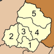
Kapong district
|
Kapong กะปง |
|
|---|---|
| Province: | Phang Nga |
| Surface: | 588.793 km² |
| Residents: | 13,950 (2012) |
| Population density : | 22.0 U / km² |
| ZIP : | 82170 |
| Geocode : | 8203 |
| map | |

|
|
Amphoe Kapong ( Thai : อำเภอ กะปง ) is a district ( amphoe - administrative district) in Phang Nga Province . The Phang Nga Province is located in the southern region of Thailand .
geography
Neighboring counties and areas are (clockwise from north): Amphoe Phanom of Surat Thani Province and Amphoe Mueang Phang Nga , Amphoe Thai Mueang and Amphoe Takua Pa of Phang Nga Province.
The county's forests are part of the Khao Lak-Lam Ru National Park .
administration
Provincial Administration
Amphoe Kapong is divided into five subdistricts ( tambon ) , which are further subdivided into 22 village communities ( muban ) .
|
Local administration
Tha Na ( เทศบาล ตำบล ท่า นา ) is a small town ( Thesaban Tambon ) in the district, it consists of parts of the Tambon Tha Na.
There are also four "Tambon Administration Organizations" (TAO, องค์การ บริหาร ส่วน ตำบล ) for the Tambon or the parts of Tambon in the county that do not belong to any town.
Individual evidence
- ↑ Population statistics 2012 . Department of Provincial Administration. Retrieved July 11, 2014.
Web links
Coordinates: 8 ° 42 ' N , 98 ° 24' E

