Karaburna
| Karaburna | ||||
|
||||
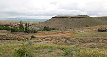
 View from Table Mountain |
||||
| Basic data | ||||
|---|---|---|---|---|
| Province (il) : | Nevşehir | |||
| District ( ilçe ) : | Hacıbektaş | |||
| Coordinates : | 38 ° 53 ' N , 34 ° 28' E | |||
| Height : | 1053 m | |||
| Residents : | 1,201 (2015) | |||
| Telephone code : | (+90) 384 | |||
| Postal code : | 50800 | |||
| License plate : | 50 | |||
| Structure and administration (as of 2016) | ||||
| Muhtar : | Mehmet Ali Kepil | |||
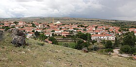
Karaburna (formerly also Karaburun ) is a village in the Hacıbektaş district of the Turkish province of Nevşehir . The place is about ten kilometers southwest of the county seat and 35 kilometers northwest of the provincial capital Nevşehir . A country road leads from Hacıbektaş via Aşıklar to Karaburna. The place is located on a small tributary of the Kızılırmak . This is dammed up to a lake east of the village and flows into the Kızılırmak about seven kilometers south. Until 2012, the place was a municipality with the last 1308 inhabitants and was then downgraded to a village.
In the west of the village there is a 90 meter high table mountain, on the plateau of which traces of a Hittite fortress have been found. The walls of the castle have been completely removed and built into the village. In the east of the plateau, the late Hittite rock inscription of Karaburna is engraved on the site of an earlier castle gate .
Individual evidence
- ↑ Nevşehir'in Belde ve Köylerinin Nüfus Sayım Sonuçları , accessed on July 19, 2016
- ↑ Hacıbektaş Belediyesi
- ↑ Yerelnet


