Karnin (Usedom)
|
Karnin
City of Usedom
Coordinates: 53 ° 50 ′ 44 ″ N , 13 ° 51 ′ 47 ″ E
|
|
|---|---|
| Height : | 8 m above sea level NHN |
| Incorporation : | July 1, 1961 |
| Postal code : | 17406 |
| Area code : | 038372 |
|
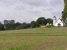
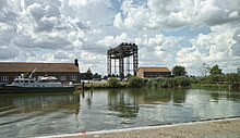
Pilot tower and railway lift bridge
|
|
Karnin is a district of the town of Usedom of the Usedom-Süd office in the Vorpommern-Greifswald district in Mecklenburg-Western Pomerania .
geography
The place is five kilometers southwest of the city of Usedom and eleven kilometers east of Anklam . Neighboring towns, which are also on the island of Usedom , are Zecherin and Kölpin in the northwest, Gneventhin in the north, Gellenthin , Usedom and Wilhelmsfelde in the northeast and Mönchow in the southeast. On the mainland there are Bugewitz , Rosenhagen and Kamp in the southwest and Anklamer ferry in the west. Carnin is located directly on the river between the Stettiner Haff and the Peene River. Due to this special location, there is also a customs office at the port.
history
Karnin was first mentioned in 1267 as "Carnyn". The Slavic name is interpreted as "small growth".
Karnin was a small and old fishing and ferry village on the backwater. The ferry connection went from Kamp to here. Since June 13, 2019, the passenger and bicycle ferry has been suspended for an indefinite period for safety reasons. In the village there was a post and a Dutch windmill, a brick factory and a pilot tower that was still operated as a special hotel.
At Karnin there was a place to live that was called "Sandford" in 1835 and "Sandfurt" in 1920. This is evidenced by the PUM (= Prussian original measuring table sheet) from 1835 and by the measuring table sheet from 1920. Whether there actually was a ford there is hardly possible, as the Peene current was too deep for that. The naming remains unclear. The term no longer appears in later maps, the living space is integrated according to Karnin. Even before that there was no discernible separation between Karnin and Sandfurt.
Karnin became important during the construction of the railway line from Ducherow to Swinoujscie. The location was used to cross the narrow point between the Peene River and the Achterwasser. As early as 1873, the construction of a bridge was chosen on the 500 meter wide point of the Peene river between the villages of Kamp and Karnin. In order to narrow the river Peene to 360 meters and thus save costs for the bridge construction, dams were built on both land and island sides. The two-armed swing bridge for single-track traffic was built between 1874 and 1876 and was clearly visible at an early stage due to its size. Until 1908 the bridge was driven manually. Then the turned parts were mechanized. It was also approved for double-track traffic that year. In the 1930s, the middle section was replaced by a lift bridge with an elevator drive. On September 15, 1933, the Karnin lift bridge was inaugurated and celebrated as the largest lift bridge in Europe. The railway bridge could carry a payload of 115 tons and was built on the model of the Rotterdam King's Bridge. At the end of April 1945, the bridge was destroyed by order of the German Wehrmacht. The elevator had been raised and the entire lifting part was not blown up in order to enable the German combat ships still in the backwater and lagoon to escape. As a result, the lifting part was preserved and in May 1988 it was placed under monument protection. The railway bridge is a considerable ruin in the middle of the Peene River.
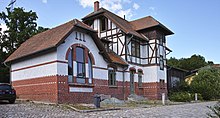
The Karnin train station was also preserved, still written “Carnin”. The station was renovated by an association and expanded as a museum for the lift bridge and for the entire railway line. The place and the train station are a tourist attraction.
On July 1, 1950, the previously independent communities Gneventhin and Zecherin were incorporated.
Culture and sights
Web links
Individual evidence
- ↑ Main statute of the city of Usedom . July 10, 2015, p. 1 , § 1 (1) ( amtusedom.de [PDF; accessed on May 30, 2016]).
- ↑ Geodata viewer of the Office for Geoinformation, Surveying and Cadastre of Mecklenburg-Western Pomerania ( information )
- ↑ Google Maps. Retrieved August 4, 2019 (de-US).
- ↑ Manfred Niemeyer: Ostvorpommern I . Collection of sources and literature on place names. Vol. 1: Usedom (= Greifswald Contributions to Place Names, Vol. 1). Ernst Moritz Arndt University of Greifswald, Institute for Slavonic Studies, Greifswald 2001, ISBN 3-86006-149-6 , p. 5 ff.
- ↑ People and bicycle ferry Kamp-Karnin out of service . Outdooractive GmbH. June 13, 2019. Retrieved August 15, 2019.
- ↑ Usedom pilot tower. Lotsenturm GmbH, accessed on July 30, 2017 .


