Kastro Agiou Vasiliou
| Kastro Agiou Vasiliou | ||
|---|---|---|
|
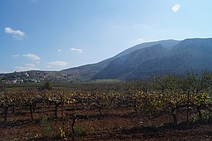
View of the castle hill and the village of Agios Vasilios below |
||
| Creation time : | Early 13th century | |
| Castle type : | Höhenburg, rocky location | |
| Conservation status: | ruin | |
| Place: | Agios Vasilios | |
| Geographical location | 37 ° 47 '16.8 " N , 22 ° 47' 52.2" E | |
| Height: | 550 m | |
|
|
||
Kastro Agiou Vasiliou ( Greek Κάστρο Αγίου Βασιλείου = castle of Agios Vasilios ) is the ruin of a Frankish rock castle in Corinthia in Greece . It is located about 500 m south of the village of Agios Vasilios on a 550 m high rock northwest below Mount Dafnias .
history
A cave to the west below the castle was already settled in prehistoric times, as shown by pottery shards and obsidian finds in the cave and in the Chouni Gorge below. At the highest point there was a fortification in the Mycenaean period . This presumably protected the road from Mycenae over the Arachneo Mountains and finally through the gorge to Zygouries .
The medieval castle was built between the conquest of the Franks during the Fourth Crusade , which took place in 1205, and 1250. In the 14th century, the Acciaiuoli family owned the castle, as evidenced by a list of income from Niccolò Acciaiuoli from 1365. After a restoration it had developed into one of the most important centers of Corinthia. 1377 it appears in the list of the nine castles castellany of Corinth .
In 1395 Carlo I Tocco , the despot of Epirus , inherited the castle and ceded it to Theodor I Palaiologos . When the Ottomans advanced against Theodor I, he saw only one way to protect the land from their access: He sold it to the Order of Malta in Rhodes . So Kastro Agiou Vasiliou came into the possession of the knightly order. But as early as 1404, when the danger was over, he bought it back.
In 1458 Sultan Mehmed II conquered Corinthia and the Kastro Agiou Vasiliou castle. In 1463 the Venetian Bartoldo II. D'Este invaded Corinthia and occupied the castle. However, he could be driven out again in the same year. In the years 1467, 1469 and 1471 the castle was sacked.
In April 1941, the residents fled from the Wehrmacht and hid in the cave below the castle.
description
The castle lies on a rock ridge that drops from south to north from about 550 m to 480 m. It has a north-south extension of 225 m, from west to east of 130 m and an area of about 1.7 hectares . Since the terrain slopes steeply in the north and west, the castle was only fortified by a wall in the south and east. The eastern wall was reinforced by four towers, the southern by two. The main entrance was in the south at the highest point. There was also a small, triangular area of about 250 m², which was separated from the castle by a wall.
Today there are numerous ruins of houses inside. The castle was supplied with water from a spring about 1.5 km southeast on the other side of the Dafnias near the church of Agia Triada Stefanoi. In the 1980s, when the road was being built 300 m east of the castle, an aqueduct made of terracotta pipes with a diameter of 15 cm was discovered.
literature
- Antoine Bon: La Morée franque: Recherches historiques, topographiques et archéologiques sur la principauté d'Achaïe (1205–1430) , 1969 Paris
Web links
Individual evidence
- ^ Ferdinand Gregorovius : History of the city of Athens in the Middle Ages. From the time of Justinian to the Turkish conquest. , Munich 1980, ISBN 3-406-07951-2 , p. 458
- ^ Ferdinand Gregorovius: History of the city of Athens in the Middle Ages. From the time of Justinian to the Turkish conquest. , Munich 1980, ISBN 3-406-07951-2 , p. 463
- ^ Ferdinand Gregorovius: History of the city of Athens in the Middle Ages. From the time of Justinian to the Turkish conquest. , Munich 1980, ISBN 3-406-07951-2 , pp. 472-3

