Kayapa
| Municipality of Kayapa | ||
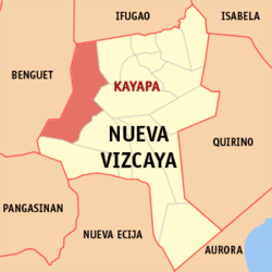
| Location of Kayapa in the Nueva Vizcaya province | ||
|---|---|---|

|
||
| Basic data | ||
| Region : | Cagayan Valley | |
| Province : | Nueva Vizcaya | |
| Barangays : | 30th | |
| District: | 1. District of Nueva Vizcaya | |
| PSGC : | 025010000 | |
| Income class : | 3rd income bracket | |
| Households : | 3506 May 1, 2000 census
|
|
| Population : | 23,714 August 1, 2015 census
|
|
| Population density : | 49.1 inhabitants per km² | |
| Area : | 482.90 km² | |
| Coordinates : | 16 ° 25 ′ N , 120 ° 55 ′ E | |
| Postal code : | 3708 | |
| Geographical location in the Philippines | ||
|
|
||
Kayapa is a municipality in the Nueva Vizcaya province of Philippines . In 2015 it had 23,714 inhabitants. Parts of the Salinas Natural Monument are on the territory of the municipality.
Kayapa is divided into the following 30 barangays :
|
|
