Kelty
| Kelty | ||
|---|---|---|
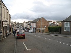
| Main street of Kelty | ||
| Coordinates | 56 ° 8 ′ N , 3 ° 23 ′ W | |
|
|
||
| Residents | 6529 2011 census | |
| administration | ||
| Post town | KELTY | |
| ZIP code section | KY4 | |
| prefix | 01383 | |
| Part of the country | Scotland | |
| Council area | Fife | |
| British Parliament | Kirkcaldy and Cowdenbeath | |
| Scottish Parliament | Cowdenbeath | |
Kelty is a town in the Scottish Council Area Fife . It is about three kilometers north of Cowdenbeath and six kilometers northeast of Dunfermline . About two kilometers to the east is the Loch Ore , from which the Ore flows. The north running Kelty Burn marks the border between Fife and neighboring Perth and Kinross .
history
The village grew with the establishment of a mining settlement by the Fife Coal Company around 1872. Older are the northeastern mansion Benarty House and Villa Blair Adam . The local soccer club Kelty Hearts was founded in 1975.
In 1871 there were 793 people in Kelty. After 7750 inhabitants were counted in 1951, the number gradually fell in the following decades to 5461 in 1991. Since then, the population has increased to 6529 in 2011.
traffic
Kelty was on the A90 , which since the extension to the M90 in 1970 has now passed the town to the west. The A909 leading to Burntisland begins in Kelty . Between 1870 and 1930 Kelty had a station on the Kinross-shire Railway . In addition, there were several coal railways that were also closed at later times.
Individual evidence
- ↑ a b Entry in the Gazetteer for Scotland
- ↑ Listed Building - Entry . In: Historic Scotland .
- ↑ Listed Building - Entry . In: Historic Scotland .
- ^ Information in the Gazetteer for Scotland
- ↑ 2011 census
- ↑ Entry on railscot.co.uk

