
Västergarn Church


The church of Västergarn ( Swedish Västergarns kyrka ) is in that Swedish town on Gotland , which was the most important on the west coast in the Middle Ages because of its port next to Visby . Its heyday was probably due to the succession of the nearby, silted up Paviken in the 13th century. The place had a town-like development, which was enclosed towards the country (as with Haithabu ) by a semicircular wall, which is still largely preserved today. In the dispute between Visby and the flat country, which ended with the defeat of the peasants in the civil war of 1288, Västergarn seems to have been important as the main town of the rural population. The church belongs to the parish (Swedish: församling) Sanda, Västergarn och Mästerby.
location
Västergarn is on road 140 from Visby to Klintehamn , 24 km south of Visby and 7 km north of Klintehamn.
Church building
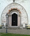
The church of Västergarn consists of a single almost square room, which was probably built in the middle of the 13th century as a choir for a larger church building. The building was modernized at the end of the 13th century with larger window openings in the south and east. In connection with the renovation, the triumphal arch was walled up and a round-arched portal was installed, which was originally supposed to have its place in the planned nave . A console in the shape of a head above the portal indicates that the nave should be vaulted . The construction could probably not be completed because the civil war led to an economic decline. Today the choir alone serves as a space for the church service. The room is covered by an eight-capped vaulted tent. In the rather deep north wall there is a staircase that leads to the roof turret. In the eastern part of the north wall, a narrow, rectangular room is cut out, which serves as a sacristy .
Facility
The furnishings come mainly from the 17th century. The stalls, the pulpit placed in the north-eastern corner of the church at the height of the altar, and the gallery with paintings depicting Christ and the apostles. The sandstone altarpiece , dated 1641, shows the sacrifice of Abraham as a relief in the middle; the painting is largely original. The initials of the Danish King Christian IV (1588–1648), as well as the coat of arms of the liege lord Holger Rosencrantz and his wife Viveka Tott can be seen on the upper part . The christening from 1592 is made of two sandstone blocks in a very unusual way for Gotland. According to an inscription, the votive ship was donated in 1637 by Marcus Schröder, who was port bailiff in Västergarn and one of the most powerful men on Gotland at the time.
The church underwent a restoration of the interior in 1966 according to plans by the architect Olle Karth.
Surroundings
To the north-east of the church are the ruins of a large round fort (defense tower), which, comparable to Sundre and Öja , was probably built at the end of the 12th century. Remains of a Romanesque church building, which consisted of a choir with apse, a rectangular nave and a tower, lie northwest of the church. This first stone church in Västergarn is believed to have been built in the second half of the 12th century. The new, larger church was not built around the foundations of the old one. The foundations of the previous buildings were found almost without exception within the new churches.
Surname
The name of the parish is first recorded as Garnae in 1304 . The direction Väster was added to the name later to distinguish it from Östergarn on the east coast of Gotland. Perhaps the first evidence of the name was given by Saxo Grammaticus in the 12th century, who describes a port near Garn. This may mean the natural harbor Paviken north of Västergarn.
photos
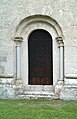
portal
unused tower arch

Västergarn Church

Runic inscription G 192 in the cemetery


literature
- Erland Lagerlöf, Gunnar Svahnström: The churches of Gotland. Stein, Kiel 1991, ISBN 3-89392-049-8 .
Web links
- guteinfo (Swedish, with pictures)
- PaGotland ( Memento from August 30, 2010 in the Internet Archive ) (Swedish)
- Orgelanders (Swedish)
- Webbgalleri Gotland (Swedish)
- Parish of Västergarn (Swedish)
- Building register at Riksantikvarieämbetet (Swedish)
Individual evidence
- ↑ Svenskt local dictionary . Språk- och folkminnesinstitutet, Uppsala 2003, ISBN 91-7229-020-X , p. 368.
Coordinates: 57 ° 26 '27.1 " N , 18 ° 9' 3.4" E