
Kirkjufell
| Kirkjufell | ||
|---|---|---|
 Kirkjufell |
||
| height | 463 m | |
| location | Iceland | |
| Coordinates | 64 ° 56 '23 " N , 23 ° 18' 5" W | |
|
||
| Type | volcano | |
| rock | u. a. Hyaloclastite | |
| Last eruption | in the last ice age | |
| particularities | previous nunatak | |


The mountain Kirkjufell ( 463 m ) lies in the west of Iceland . It is located near the town of Grundarfjörður on the western bank of the Grundarfjörður fjord of the same name in the north of the Snæfellsnes peninsula .
Surname
The name Kirkjufell, in German 'Kirchberg' , seems to come from its church tower-like shape.
Danish merchants, on the other hand, gave it the name Sukkurtoppen ( Danish ; = German, sugar loaf).
Shape and geology
The mountain stands out due to its wedge-shaped exterior and protrudes as a peninsula into the large fjord Breiðafjörður , separating the side fjord Grundarfjörður from the lagoon Hálsvaðall .
Kirkjufell has very steep slopes in all directions and owes this shape to the ice age glaciers, between which he stood out as a nunatak . So the glaciers were able to grind it from all sides.
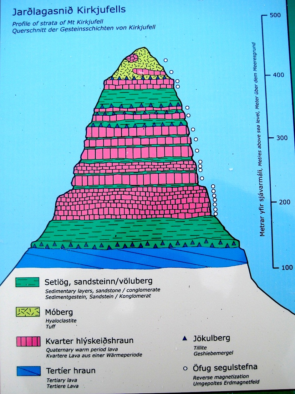
The mountain belongs to the Lýsuskarð volcanic system . Numerous geological strata can be identified on it, which generally correspond to those of other mountains in the north of Snæfellsnes ; at its foot you can find lavas from the Holocene , above alternating layers of sediment and lavas from the interglacial periods of the Tertiary . These lavas are several million years old. In between there are also layers of sediment with remains of marine life such as at Cape Búlandshöfði . The summit consists largely of hyaloclastites (tuff). This suggests that the most recent rock layers on the mountain were formed under a glacier.
Ascent
The ascent of the mountain is only recommended for those with a head for heights and can be undertaken from the southwest end. The trail is sometimes difficult to find. In the upper area there are ropes with knots in three places as a climbing aid.
Abandoned courtyards
Three abandoned farms were in the northeast at the foot of the mountain on the peninsula. The last of these courtyards was abandoned in 1945. No rich people lived here, and the little lowlands were barely enough to provide for themselves.
In earlier centuries people went fishing from there.
An anecdote from the 19th century tells of Katrin, the householder's wife on the Hlein farm . It was said that she could walk on the exposed slopes of Kirkjufell with almost sleepwalking certainty. One autumn day, Árni, the area administrator, sent her up to fetch a lost sheep. Despite the half-frozen slopes, she initially managed to find the sheep. But when she was attacked by one of the eagles that have their nests on the mountain, she crashed. To everyone's amazement, she survived the fall. She received a reward for the risk she had taken.
Trivia
The mountain and its surroundings were sometimes used as a film location for the series production of Game of Thrones .
Kirkjufell also graces the album cover of the eighth studio album Wanderer by the German metalcore band Heaven Shall Burn from 2016.
See also
- Kirkjufellsfoss
- Geography of Iceland
- Volcanoes in Iceland
- List of mountains and elevations in Iceland
Web links
Individual evidence
- ↑ a b Einar Haukur Kristjánsson, Eythór Einarsson: Snæfellsnes norðan fjalla (= Árbók / Fer · dafélag Íslands ). Ferðafélag Íslands, [Reykjavík] 1986, OCLC 85088842 , p. 51 f.
- ↑ See the blog of the geologist Haraldur Sigurdsson . Entry from April 5, 2011 , accessed on April 16, 2011 ( Icelandic , the geological sketch is also labeled in German).
- ^ Ari Trausti Guðmundsson , Pétur Þorleifsson: Íslensk fjöll. Gönguleiðir á 151 tind. Mál og Menning, Reykjavík 2004, ISBN 9979-3-2493-7 , p. 164 f .; 2009, ISBN 978-9979-3-2493-5 .
- ↑ Marc Röhlig: These are the most spectacular locations from the 7th season of "Game of Thrones". In: bento.de. August 29, 2017. Retrieved August 30, 2017.