Kittenbach (Ammersee)
| Kittenbach | ||
| Data | ||
| location | Upper Bavaria | |
| River system | Danube | |
| Drain over | Ammersee → Amper → Isar → Danube → Black Sea | |
| source | Trench at the Hübschenried estate 47 ° 58 ′ 59 ″ N , 11 ° 3 ′ 44 ″ E |
|
| Source height | 645 m above sea level NHN | |
| muzzle | in the Ammersee Coordinates: 48 ° 0 ′ 38 ″ N , 11 ° 6 ′ 2 ″ E 48 ° 0 ′ 38 ″ N , 11 ° 6 ′ 2 ″ E |
|
| Mouth height | 533 m above sea level NHN | |
| Height difference | 112 m | |
| Bottom slope | 35 ‰ | |
| length | 3.2 km | |
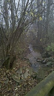
The Kittenbach is an approximately 3.2 km long tributary to the Ammersee in Upper Bavaria.
course
The creek is created as a trench a little north of the Hübschenried estate in the district of Dießen am Ammersee in a forest area and initially runs north. About half a kilometer before the source region of the Uttinger Mühlbach , it curves to the right and then straight back to the north. whereupon for a long time it flows parallel to the neighboring stream at this distance and crosses the municipal boundary to Utting am Ammersee .
From the Kittenalm on the left slope, the environment becomes more open and it now runs northeast. After the St 2055 Dießen – Utting has crossed it, it soon swings to the east and moves between Utting in the north and its suburb of Holzhausen am Ammersee on the right side towards the lake. Its cone of rubble has driven a nose about a quarter of a kilometer into this, at the tip of which it ends.
Web links
- The course of the Kittenbach on the BayernAtlas
