Kivalliq
| Kivalliq region | |
|---|---|
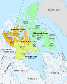
 Location of the region in Nunavut
|
|
| Basic data | |
| Country | Canada |
| territory |
Nunavut
|
| Administrative headquarters | Rankin Inlet |
| Coordinates : | 64 ° 54 ′ N , 96 ° 1 ′ W |
| Residents | 10,413 (as of 2016) |
| surface | 444,621.71 km² |
| Population density | 0 inhabitants / km² |
Kivalliq Region ( Inuktitut : ᑭᕙᓪᓕᖅ) is an administrative region of the Canadian territory of Nunavut .
It consists of a mainland portion west of Hudson Bay , and the islands of Southampton Island and Coats Island . The administrative seat is Rankin Inlet , which has 2,842 residents .
Prior to 1999, the Kivalliq Region essentially existed as the Keewatin Region with slightly changed boundaries and was part of the Northwest Territories . Although the name Kivalliq has been official since 1999, Statistics Canada continued to refer to the area as the "Keewatin Region, Nunavut" in publications such as the Census .
Communities
![]() Map with all coordinates: OSM | WikiMap
Map with all coordinates: OSM | WikiMap
| local community | Inuktitut | Inuktitut syllabary |
Area ( km² ) |
Population (2016 census) |
Coordinates |
|---|---|---|---|---|---|
| Eskimo Point | Arviat | ᐊᕐᕕᐊᑦ | 132.07 | 2,657 | 61 ° 6 ′ 29 ″ N , 94 ° 3 ′ 25 ″ W. |
| Baker Lake | Qamanittuaq | ᖃᒪᓂᑦᑐᐊᖅ | 182.22 | 2,069 | 64 ° 19 ′ 5 ″ N , 96 ° 1 ′ 3 ″ W. |
| Chesterfield Inlet | Igluligaarjuk | ᐃᒡᓗᓕᒑᕐᔪᒃ | 141.10 | 437 | 63 ° 20 ′ 27 " N , 90 ° 42 ′ 22" W. |
| Coral Harbor | Salliq | ᓴᓪᓕᖅ / ᓴᓪᓖᑦ | 137.91 | 891 | 64 ° 8 ′ 13 ″ N , 83 ° 9 ′ 51 ″ W. |
| Rankin Inlet | Kangiqiniq | ᑲᖏᕿᓂᖅ | 20.24 | 2,842 | 62 ° 48 ′ 38 " N , 92 ° 5 ′ 9" W. |
| Repulse Bay | Naujaat | ᓇᐅᔮᑦ | 424.27 | 1,082 | 66 ° 31 ′ 19 " N , 86 ° 14 ′ 6" W. |
| Whale Cove | Tikiraqjuaq | ᑎᑭᕋᕐᔪᐊᖅ | 283.66 | 435 | 62 ° 10 ′ 22 ″ N , 92 ° 34 ′ 46 ″ W. |
| unorganized 1 | 443,299.63 | 0 | |||
| Keewatin | Kivalliq | ᑭᕙᓪᓕᖅ | 444,621.71 | 10,413 |
Demographics
| census | region | Nunavut | ||
|---|---|---|---|---|
| Residents | Change in% |
Residents | Change in% |
|
| 2016 | 10,413 | + 16.3 | 35,944 | + 12.7 |
| 2011 | 8,955 | + 7.3 | 29,474 | + 8.3 |
| 2006 | 8,348 | + 10.5 | 29,474 | + 10.2 |
| 2001 | 7,557 | + 10.0 | 26,745 | + 8.1 |
| 1996 | 6,868 | + 17.7 | 24,730 | |
| 1991 | 5,834 | |||
Protected areas
- Ukkusiksalik National Park
- Inuujarvik Territorial Park
- Iqalugaarjuup Nunanga Territorial Park
- East Bay Migratory Bird Sanctuary
- Harry Gibbons Migratory Bird Sanctuary
- McConnell River Migratory Bird Sanctuary
- Thelon Wildlife Sanctuary
- Arvia'juaq National Historic Site
- Fall Caribou Crossing National Historic Site
Web links
- Kivalliq Region information at Explore Nunavut
- KIVALLIQ.COM Photos, Information lnks from Rankin Inlet Nunavut
Individual evidence
- ^ Census Profile, 2016 Census. In: Statistics Canada . February 9, 2017, accessed August 7, 2020 .
-
↑ Statcan: 6205033 - Keewatin, Unorganized: Place name (s) :
- Ennadai ( 61 ° 8 ′ 2 ″ N , 100 ° 53 ′ 3 ″ W )
- Fullerton ( 63 ° 59 ′ 59 ″ N , 88 ° 58 ′ 52 ″ W )
- Maguse River ( 61 ° 16 ′ 52 ″ N , 94 ° 3 ′ 46 ″ W )
- Padlei ( 61 ° 56 ′ 2 ″ N , 96 ° 40 ′ 2 ″ W )
- Tavani ( 62 ° 4 ′ 2 ″ N , 93 ° 6 ′ 30 ″ W )
- Wager Bay ( 65 ° 56 ′ 3 ″ N , 90 ° 49 ′ 0 ″ W )
- ^ Census Profile, 2016 Census. Subprovincial geography levels: Nunavut. In: Statistics Canada . February 9, 2017, accessed August 7, 2020 .
- ^ Census Profile, 2011 Census. Subprovincial geography levels: Nunavut. In: Statistics Canada . November 27, 2015, accessed on August 7, 2020 .
- ↑ 2006 Community Profiles. In: Statistics Canada . August 21, 2019, accessed on August 7, 2020 .
- ↑ 2001 Community Profiles. In: Statistics Canada . July 2, 2019, accessed on August 7, 2020 .
- ^ Profile of Census Divisions and Subdivisions, 1996 Census. In: Statistics Canada . December 23, 2013, accessed August 7, 2020 .
