
Kleine Pleiße (Rötha)
|
Kleine Pleiße Kleine Pleiße Rötha |
||
 The Kleine Pleiße in the Rötha Castle Park |
||
| Data | ||
| location | Saxony , Germany | |
| River system | Elbe | |
| Drain over | Pleiße → Weisse Elster → Saale → Elbe → North Sea | |
| source | Junction from the Pleiße at the Gaulis weir 51 ° 11 ′ 18 ″ N , 12 ° 24 ′ 20 ″ E |
|
| muzzle | Via Neumühlgraben near Böhlen to the Pleiße Coordinates: 51 ° 12 '9 " N , 12 ° 23' 55" E 51 ° 12 '9 " N , 12 ° 23' 55" E
|
|
| length | 2.5 km | |
| Catchment area | 7 km² | |
| Small towns | Rötha , Böhlen | |
The Kleine Pleiße (also Kleine Pleiße Rötha ) is a formerly natural, later artificially shaped branch of the Pleiße near Rötha in Saxony . It is to be distinguished from the eponymous runoff of the Markkleeberger See south of Leipzig .
course
The Kleine Pleiße branches off at the Pleissewehr Gaulis to the east and runs in a northerly direction in meanders through a forest area on the northeast bank of the Rötha reservoir. At the city limits of Rötha, it absorbs the runoff water from the Rötha reservoir and flows along the building boundary. The Rietzschke stream, which comes from the east and has piped under the city, flows here. On the site of the former Rötha estate and castle, she enters the castle park, which she crosses to the Rötha – Böhlen road (S72). After crossing under the street, it continues to flow north until it turns sharply to the southwest at the embankment of the former Böhlen – Espenhain railway line . Along the railway embankment, it reaches the Neumühlgraben, and after about 150 meters it flows into the Pleiße near Böhlen .
The lake inlet branching off from the Pleiße south of the reservoir is also called Kleine Pleiße.
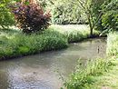
Branch of the Kleine Pleiße at the Gaulis weir
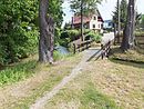
Association with the outflow reservoir Rötha
In the Röthaer Schlosspark

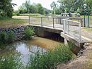
Crossing under the Böhlen – Rötha road (S72)


history
The Kleine Pleiße formerly branched off naturally from the Pleiße north of Trachenau without any damming and flowed as a tributary east of the Pleiße in the flat Pleißetal, partly with branching ditches towards Rötha. Here it drove the castle mill and was branched several times in the area of the castle and the park as a castle moat and for park design. After Rötha it flowed further north in a natural bed past Geschwitz and after a few meanders in front of turnips it flows into the mill ditch there.
The first interventions in the southern part of the Kleine Pleiße resulted from the construction of the Rötha reservoir in the years 1938 to 1940. Finally, the northern part around Geschwitz was dredged by the Espenhain opencast mine and the southern part around Trachenau by Witznitz II (now Kahnsdorfer See ), which eventually led to today's course.
use
In addition to the drainage of the corridor areas west of Rötha and the drainage of excess water from the Rötha reservoir, the Kleine Pleiße is also important for fishing.
Web links
Individual evidence
- ↑ Model project for spatial planning (MORO) "Spatial development strategies for climate change" Regional Planning Association Leipzig Westsachsen, Dresden, March 2010, on: klimamoro.de (pdf; 4.4 MB)
- ↑ Pleiße flood protection concept in the Leipzig administrative district, location Rötha. Retrieved June 3, 2015 .
- ^ SLUB Dresden : Meilenblätter von Sachsen (1802) sheet 42 as well as topographical map (equidistant map) Saxony (1876-1936), sheet 26 and sheet 42
- ↑ Kleine Pleiße Rötha. (No longer available online.) In: Anglerverband Leipzig eV Archived from the original on June 5, 2015 ; Retrieved June 5, 2015 .