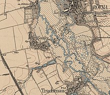
Gaulis
|
Gaulis
City of Böhlen
Coordinates: 51 ° 11 ′ 15 " N , 12 ° 23 ′ 48" E
|
|
|---|---|
| Height : | 130 m above sea level NN |
| Residents : | 231 (May 9, 2011) |
| Incorporation : | 1935 |
| Incorporated into: | Trachenau |
| Postal code : | 04564 |
| Area code : | 034206 |
Gaulis is a district of the city of Böhlen in the Leipzig district in the south of the Leipzig lowland bay .
Location and local characteristics

Gaulis is located on the western edge of the Pleißenaue about 1.7 kilometers south-southeast of the center of Böhlen. The distance to the Rötha reservoir is around 600 meters.
Neighboring Gaulis from the north are the main town Böhlen, Rötha, the Rötha reservoir, the Kahnsdorfer See , Kahnsdorf , Pürsten, Neukieritzsch , Kieritzsch, Lippendorf and the industrial area Böhlen-Lippendorf. Because of the redesign south of Gaulis due to opencast mining, there is only a road connection to Böhlen.
Originating from a farming village, it has retained its village character to this day. Since the 1990s it has been a preferred residential area of Böhlen, among other things because of its proximity to the Rötha reservoir and the Kahnsdorfer See. Numerous new houses were built.
history
Gaulis was first mentioned as Jaules in 1303. It is to be regarded as a Sorbian foundation and consisted of two round hamlets lying close together . The mill was a bit out of the way, near Pleiß. In 1551 there were 28 farms in Gaulis. Manorial it was under at that time the manor royal box at Rochlitz . That changed later, in 1764 it belonged to the Rötha manor. With the first Saxon constitution of 1831 and the Saxon rural community order of 1838 , Gaulis became a self-governing municipality without any manorial dependency. The place was until 1856 in the Electoral Saxon or Royal Saxon District Office Leipzig . From 1856 the place belonged to the Rötha court office and from 1875 to the Borna district administration . Gaulis never had a school or a church. Since the Middle Ages, it was parish in the southeastern neighboring Trachenau , where the children also went to school.
Around 1900 the Leipzig city council and banker Heinrich Dodel acquired extensive property north of Gaulis in order to build a residential area for wealthy Leipzig residents. It all started with a romantic park with exotic trees and plants as the center and a villa-like restoration building . Fortunapark and -villa, as the facility was called, were all that could be realized from the project. Later the villa fell into disrepair and had to be demolished, the park deteriorated.
The beginning of the 1920s which had Aktiengesellschaft Saxon works the open pit Bohlen unlocked for the extraction of lignite, their processing from 1925 about a kilometer was done in a briquetting plant and a power plant west of Gaulis. From the 1940s, the carbochemical industry was added, which was significantly expanded during the GDR era. In connection with the environmental policy of the GDR, this led to Gaulis becoming one of the most polluted places in the Leipzig region. That changed fundamentally with the introduction of environmentally friendly technologies in the 1990s. The old Lippendorf power plant was replaced by a modern new one in 2000 .
In 1935 Gaulis was incorporated into the neighboring larger Trachenau. When this had to give way to the Witznitz II opencast mine in the early 1960s , Gaulis came to Böhlen on July 1, 1964 with the devastated corridor of Trachenau and Treppendorf. At the time of German reunification in 1989/90, Gaulis himself was affected by the planned resettlement and devastation by the Witznitz II opencast mine. By 2015, around 50 million tons of coal should be mined in the Gaulis mining field. However, the change in economic policy that accompanied German reunification led to a drastic decline in the demand for lignite, which meant that the open-cast mine was shut down early by 1993 despite the presence of deposits. Thus, Gaulis was spared the resettlement and demolition, only ten residents were affected by the resettlement in 1989. South of the village, the Gaulis dump is a witness of lignite mining near the village.
Historic buildings and landmarks
In the middle of the village there is a memorial for those who died in the war between 1914 and 1918. Further west on Spahnsdorfer Weg is a well-maintained playground. In the east of Gaulis it is only with a lot of imagination that you can imagine what the still intact watermill looked like there.
literature
- In the Pleiße and Göselland between Markkleeberg, Rötha and Kitzscher - published by PRO LEIPZIG eV, Leipzig 1999
Web links
- Gaulis on the website of Böhlen
- Gaulis in the Digital Historical Directory of Saxony
- Gaulis . In: August Schumann : Complete State, Post and Newspaper Lexicon of Saxony. 3rd volume. Schumann, Zwickau 1816, p. 47.
- About the Fortunapark
Individual evidence
- ↑ Small-scale municipality gazette. (PDF; 670 KB) 2011 census - Böhlen, city. State Statistical Office of the Free State of Saxony , p. 5 (p. 7 in PDF) , accessed on December 10, 2016 .
- ^ Karlheinz Blaschke , Uwe Ulrich Jäschke : Kursächsischer Ämteratlas. Leipzig 2009, ISBN 978-3-937386-14-0 ; P. 60 f.
- ^ The Borna District Administration in the municipal directory 1900
- ↑ The Witznitz opencast mine with a map on the LMBV website


