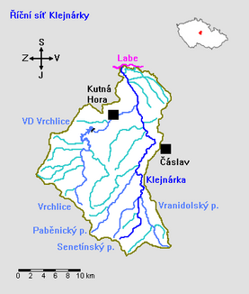
Klejnarka
| Klejnarka | ||
|
River course |
||
| Data | ||
| location | Czech Republic | |
| River system | Elbe | |
| Drain over | Elbe → North Sea | |
| source | as Janský potok southeast of Dědice ( Petrovice I ) | |
| Source height | 516.5 m nm | |
| muzzle | opposite Tři Dvory in the Elbe Coordinates: 50 ° 1 ′ 14 ″ N , 15 ° 16 ′ 25 ″ E 50 ° 1 ′ 14 ″ N , 15 ° 16 ′ 25 ″ E |
|
| Mouth height | 193.6 m nm | |
| Height difference | 322.9 m | |
| Bottom slope | 8th ‰ | |
| length | 40.3 km | |
| Catchment area | 350 km² | |
| Drain |
MQ |
1.32 m³ / s |
| Left tributaries | Krchlebský potok, Senetínský potok, Paběnický potok, Medenický potok, Olšanský potok, Křenovka, Vrchlice | |
| Right tributaries | Vranidolský potok | |
| Small towns | Čáslav | |
The Klejnárka is a left tributary of the Elbe in the Czech Republic .
course
The Klejnárka rises as Janský potok southeast of the district Dědice of the municipality Petrovice I in 516.5 m. ü. M. in the Bohemian-Moravian Highlands .
The towns of Dobrovítov , Čejkovice , Zbýšov and Opatovice are located on its northward course . At Hraběšín , the stream in Krchlebská dubina winds through a rocky valley. At Chedrbí the Paběnický potok flows into, from its confluence the water is called Klejnárka . Via Vodranty , Krchleby and Močovice , the further course leads west past Čáslav . The further course leads past Třebešice , Církvice , Jakub, Ovčáry, Nové Dvory , Malín and Hlízov east of Kutná Hora . Here the Klejnárka leaves the Bohemian-Moravian Highlands and flows past Starý Kolín over the southeastern part of the Bohemian Table. Opposite Tři Dvory the river flows after 40.3 km at an altitude of 193.6 m. ü. M. in the Elbe . The catchment area of the river is 350 km².
Tributaries
- Krchlebský potok (l), Opatovice
- Senetínský potok (l), Doudovský mlýn
- Vranidolský potok (r), Doudovský mlýn
- Paběnický potok (l), Chedrbí
- Medenický potok (l), Vodranty
- Olšanský potok (l), Třebešice
- Křenovka (l), Církvice
- Vrchlice (l), Nové Dvory
