Koki lakes
| Koki lakes | ||
|---|---|---|

|
||
| Geographical location | Rakai District ; Mbarara District , Uganda , East Africa | |
| Tributaries | Ruizi ; Rainfall | |
| Drain | Kibals ; evaporation | |
| Islands | many (marshland) | |
| Places on the shore | Rakai (on Lake Kijanebalola) | |
| Location close to the shore | Mbarara | |
| Data | ||
| Coordinates | 0 ° 40 ′ 0 ″ S , 31 ° 5 ′ 0 ″ E | |
|
|
||
| Altitude above sea level | 1226-1250 m | |
| surface | 259.5 km² | |
| length | Max. 70 km (entire complex) | |
| width | Max. 25 km (entire complex) | |
| Maximum depth | 4.8 m | |
|
particularities |
Lake complex |
|

|
||
| The Koki Lakes | ||
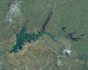
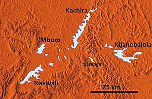
The Koki Lakes, also referred to in some sources as the Kijanebalola Swamp Complex, are a lake system in southwest Uganda . The name is derived from the Koki people who live in this area, as is the official name for this part of Uganda (Koki County). The lake group consists of four larger and a large number of smaller lakes, which are connected by papyrus swamps. These are the remains of a larger lake that is almost silted up to its side arms.
Geology / hydrology

The Ruizi River is the largest tributary to the Koki Lakes. However, they also receive ample input from precipitation through the numerous slopes of the surrounding hills. The Koki Lakes are now drained in an easterly direction via the Kibale River into Lake Victoria , but in earlier periods they were drained to the west. From the westernmost lake (Lake Nakivali) there are reports that during floods the eastern outflow can be blocked by clogging by floating papyrus islands and then also to an outflow over the Orichinga valley in the west in a southerly direction to the Kagera river. Most of the water in the Koki Lakes is not lost through runoff, but through evaporation. The waters have a slightly alkaline character (pH: 7.2–8.5). The lake floors are sealed by thick layers of clay and therefore hardly lose any water below. The oldest underground rock in this area consists of a laterite plate. During an earlier humid period, when Lake Victoria had its highest water level, its extension reached up into the Kagera Valley, to about southeast of Rugaga. At that time, the Koki Lakes were connected to Lake Victoria by the Orichinga Valley and gaps in the sediment cones.
The largest lakes are from west to east:
- Lake Nakivali ( 0 ° 49'-0 ° 44'S; 30 ° 50'-30 ° 56'E ); approx. 12 km extension in a northeasterly direction
- Mburo Lake ( 0 ° 41'-0 ° 38'S; 30 ° 54'-30 ° 57'E ); approx. 6.7 km extension in a northeasterly direction
- Lake Kachira ( 0 ° 40'-0 ° 30'S; 31 ° 04'-31 ° 09'E ); approx. 20 km extension in a northeasterly direction
- Lake Kijanebalola ( 0 ° 37'-0 ° 44'S; 31 ° 13'-31 ° 24'E ); approx. 20 km extension in a slightly southeastern direction
Other small lakes are (in alphabetical order):
- Bwarasee
- Kasasa lake
- Kazuma Lake
- Karitima lake
- Kiretwasee
- Karunga Lake
- Lake Mikera
- Mutukura lake
- Rubondo Lake
- Rumasee
Protected areas
The Lake Mburo National Park extends with its southern part into the swamp area. It surrounds Lake Mburo and borders the western shore of Lake Kachira.
Economic use
The area is important for agriculture, especially livestock husbandry, and fishing (species relevant to fishing are e.g. the cichlid genus Oreochromis , gill sack catfish ( Clarias sp.) And lungfish ( Protopterus aethiopicus )). Many smaller, partly endemic species, some of which have not yet been scientifically described, live in the waters. The lakes partially serve as water reservoirs for agricultural areas outside. However, plans from the 1960s to expand this even further (e.g. by building dams) have been rejected or still not implemented.
swell
- Hughes, RH and Hughes, JS: A directory of African wetlands . IUCN / UNEP / WCMC, 1992.
- Kramer, EW and Stegemann, B .: Report to the Government of Uganda on the Koki Lakes Reconnaissance Survey; Report No. 2213 . FAO, Rome, 1965.
- Schraml, E .: The biodiversity of fish in Uganda's waters. Contributions to the knowledge of Uganda's fish fauna. DCG information Special No. 3: 2-48 . German Cichlid Society, 2004, ISSN 0724-7435 .
Web links
- ↑ A directory of African wetlands: Uganda ( Memento of the original from May 6, 2012 in the Internet Archive ) Info: The archive link was inserted automatically and not yet checked. Please check the original and archive link according to the instructions and then remove this notice. (PDF; 178 kB)
- ↑ Location of the Koki Lakes on Google Maps
- ↑ The biodiversity of fish in Uganda's waters (PDF; 7.5 MB)


