Koktscha
|
Koktscha Kowkcheh |
||
| Data | ||
| location | Badachschan , Tachar ( Afghanistan ) | |
| River system | Amu Darya | |
| Drain over | Pandsch → Amu Darya → Aral Sea (temporarily) | |
| Confluence of |
Jachschindar and Mundschan in the Hindu Kush 36 ° 1 ′ 35 ″ N , 70 ° 43 ′ 16 ″ E |
|
| Source height | approx. 3530 m | |
| muzzle |
Pandsch coordinates: 37 ° 9 ′ 50 ″ N , 69 ° 24 ′ 7 ″ E 37 ° 9 ′ 50 ″ N , 69 ° 24 ′ 7 ″ E |
|
| Mouth height | 413 m | |
| Height difference | approx. 3117 m | |
| Bottom slope | approx. 8.7 ‰ | |
| length | approx. 360 km (including source river Mundschan ) | |
| Catchment area | approx. 20,700 km² | |
| Discharge at the Jurm A Eo gauge : 7670 km² |
MQ 1969/1978 Mq 1969/1978 |
74.1 m³ / s 9.7 l / (s km²) |
| Discharge at the Keshem A Eo gauge : 16,765 km² |
MQ 1969/1978 Mq 1969/1978 |
160 m³ / s 9.5 l / (s km²) |
| Discharge at the Khojaghar A Eo gauge: 20,645 km² Location: 11 km above the mouth |
MQ 1964/1978 Mq 1964/1978 |
198 m³ / s 9.6 l / (s km²) |
| Left tributaries | Keshem | |
| Right tributaries | Warduj | |
| Medium-sized cities | Faizabad | |
|
Koktscha in Faizabad |
||
|
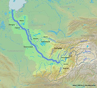
The course of the Koktscha river can be seen east of Kunduz (Qonduz) |
||
The Koktscha (also Kowkcheh ) is a left tributary of the Pandsch in the provinces of Badachschan and Tachar in the north of Afghanistan .
The Koktscha originates in the province of Badachschan on the northern flank of the Hindu Kush at the confluence of the Jachschindar and Mundschan rivers . It initially flows through the mountains in a gorge in a northerly direction. It passes the provincial capital Faizabad and then turns to the northwest, later to the southwest and finally to the northwest again. They crossed the border with the province of Takhar and finally ends at the border with Tajikistan in the Panj, the left source river of Amu Darya .
The Koktscha together with its source river Mundschan has a length of about 360 km. The mean discharge is 180 m³ / s. The river floods in spring and summer . Some of the river water is diverted for irrigation purposes .
Hydrometry
Average monthly discharge of the Koktscha (in m³ / s) at the Khojaghar gauge
measured from 1964–1978


