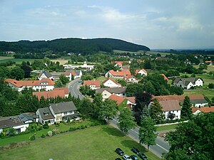
Kollwesshöh
| Kollwesshöh | ||
|---|---|---|
|
The Kollwesshöh (rear right crest) seen from Haldem |
||
| height | 181.4 m above sea level NHN | |
| location | at Westrup ; District of Minden-Lübbecke , North Rhine-Westphalia ( Germany ) | |
| Mountains | Stemweder Berg | |
| Coordinates | 52 ° 26 '8 " N , 8 ° 26' 0" E | |
|
|
||
| particularities | highest elevation of the North German lowlands north of the Bückeberge | |
The Kollwesshöh near Westrup in the Minden-Lübbecke district in North Rhine-Westphalia is 181.4 m above sea level. NHN in front of the west-northwest neighboring Scharfen Berg the highest elevation of the Stemweder Berg , the smallest and northernmost low mountain range of Germany , and at the same time the highest elevation of the North German lowlands north of the Bückeberge .
Name origin
The mountain name consists of two parts: Kollwess and höh .
The first part comes from the fact that the land on the elevation, also known as mountain parts, used to belong to the Kohlwes family in Wehdem . The second part is self-explanatory. Due to errors when transferring from other maps or the spelling of the surname, which was still partially different in the 19th century, the name Kollwesshöh came about .
geography
location
The Kollwesshöh is part of the Stemweder Berg in the Dümmer Nature Park , north of Westrup , a northern part of Stemwede . Its summit belongs to the demarcation of the northeastern Stemweder district of Wehdem . You can reach the Kollwesshöh, for example, via Westrup in a north-westerly direction with forest paths connecting the Scharfen Berg .
Natural allocation
The Kollwesshöh belongs to the natural spatial main unit group Dümmer-Geestniederung (No. 58), in the main unit Rahden-Diepenauer Geest (582) and in the subunit Stemmer Heights (582.0) to the natural area Stemmer Berge (582.00).
history
Almost 1 km north of the Kollwesshöh there is a noteworthy barrow from the Bronze Age on the “White Way” .

