Sharp mountain
| Sharp mountain | ||
|---|---|---|
|
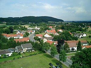
The sharp mountain (front left crest) seen from Haldem |
||
| height | 180.1 m above sea level NHN | |
| location | at Arrenkamp ; District of Minden-Lübbecke , North Rhine-Westphalia ( Germany ) | |
| Mountains | Stemweder Berg | |
| Coordinates | 52 ° 26 '14 " N , 8 ° 25' 15" E | |
|
|
||
| particularities | Location of a broadcasting system for West German Broadcasting | |
The sharp mountain near Arrenkamp in the North Rhine-Westphalian district of Minden-Lübbecke is 180.1 m above sea level. NHN is the second highest elevation of the Stemweder Berg , the smallest and most northerly low mountain range in Germany, after the east-southeast neighboring Kollwesshöh .
geography
location
The Scharfe Berg is part of the Stemweder Berg, located in the Dümmer Nature Park , north of Arrenkamp , a northern part of the municipality of Stemwede . Its summit belongs to the demarcation of the northeastern Stemweder district of Wehdem . The border with Lower Saxony runs around 850 m north of the hilltop. The Scharfen Berg can be reached, for example, via the “White Path”, which comes from Oppendorf and ends at the “Berggasthof Wilhelmshöhe” (approx. 160 m ) near the mountain near Haldem on the border with Wehdem.
Natural allocation
The Lange Berg belongs to the natural spatial main unit group Dümmer-Geestniederung (No. 58), in the main unit Rahden-Diepenauer Geest (582) and in the subunit Stemmer Heights (582.0) to the natural area Stemmer Berge (582.00).
history
Around 1.2 km northeast of the Scharfen Berg there is a barrow from the Bronze Age on the “White Way” . Much later, sand-lime bricks were mined on the mountain , which can be seen from an abandoned quarry .
At the beginning of the 20th century, a wooden observation tower was built on the southern mountain flank above the Stemweder district of Arrenkamp . With good visibility (up to 50 km) you could see the Dümmer , the Kellenberg , the Wiehengebirge with the Kaiser Wilhelm monument at the Porta Westfalica , a piece of the Weser Mountains , the Dammer Mountains and many other villages. The tower was demolished in 1939 due to its dilapidation. As before, views can be enjoyed from the partly unwooded mountain slopes.
On the northern part of the summit region of Mount Sharp is a radio - transmitter of the West German Radio (WDR).
Flora and geology
Near the Scharfen Berg, on Wilhelmshöhe and in a cross valley called "Hilige Dehne" at the foot of the ridge, there are orchards from which you have a good view of the area. The shell limestone layer of the mountain also produces a flora that is completely different from the species for north-west Germany .
West German Broadcasting System
Digital radio (DAB)
DAB or the successor standard DAB + is broadcast in vertical polarization and in single-frequency mode with other transmitters. On August 29, 2012 the change from DAB channel 12D to DAB channel 11D took place. The multiplex radio for NRW with the programs of WDR and Domradio with an output of 1.5 kW ERP is currently being transmitted via this ; until 2015 Radio Impala was also broadcast.
| block | Programs (data services) |
ERP (kW) |
Antenna diagram round (ND), directional (D) |
Polarization horizontal (H) / vertical (V) |
Single frequency network (SFN) |
|---|---|---|---|---|---|
| 11D radio for NRW (D__00236) |
|
1.5 | ND | V |
|


