
Kronau Colony
The county Kronau (today Ukrainian Wyssokopillja / Високопілля) was a settlement of ethnic German ( Black Sea German ) in the field of Kherson Oblast today's Ukraine .
Settlements in the administrative district of Kronau
- No. 1: Eigenfeld (Suworowka, today parts of Iwaniwka / Іванівка)
- No. 2: Schöntal (today part of Olhyne / Ольгине)
- No. 3: Landau (today Potjomkyne / Потьомкине)
- No. 4: Ebenfeld (destroyed, east of Vysokopillja)
- No. 5: Fürstental (northern part of Vysokopillja)
- No. 6: Nikolaital (today Topolyne / Тополине)
- No. 7: Fürstenfeld (today Knjasiwka / Князівка)
- No. 8: Kronau (today Wyssokopillja / Високопілля)
- No. 9: Eigental (today Olhyne / Ольгине)
- No. 10: sand field (20 kilometers west of Vysokopillja)
- No. 11: Neu-Mannheim (today the eastern part of Wyssokopillja)
- Hochfeld (11 kilometers west of Vysokopillja)
- Grünfeld (10 kilometers west of Wyssokopillja)
- Katerintal?
- Kneisler?
- Tartar?
such as
- No. 1: Alexanderfeld (today Nowooleksandriwka / Новоолександрівка)
- No. 2: Neu-Schönsee (today Oseriwka / Озерівка)
- No. 3: Friedensfeld (formerly Novomyriwka / Новомирівка, northwest of Oseriwka)
- No. 4: Neu-Halbstadt (today Riwnopillja / Рівнопілля)
- No. 5: Nikolaifeld (today Mykilske / Микільське)
- No. 6: Orloff (today Orlowe / Орлове)
- No. 7: Flower place (today Switlivka / Світлівка)
- No. 8: Tiege (today Kotschubejiwka / Кочубеївка)
- No. 9: Altonau (today Pryhirja / Пригір'я)
- No. 10: Rosenort (today Rosiwka / Розівка)
- No. 11: Münsterberg (destroyed, north of Pryhirja)
- No. 12: Gnadenfeld (today Blahodatne / Благодатне)
- No. 13: Schönau (today Krasniwka / Краснівка)
- No. 14: Steinfeld (today Kamjanka / Кам'янка)
- No. 16: Reinfeld (until 2001 Sofijiwka / Софіївка, south of Natalyne / Наталине)
- No. 17: Alexander's crown (until 2001 Luhiwka / Лугівка, west of Switliwka)
- Deutschendorf (re-established in 1942 through relocation and renaming, today Iwaniwka / Іванівка)
Emergence
The Kronau settlement was founded between 1869 and 1870 by predominantly Evangelical Lutheran Germans from the area of the Taurian Prischiber mother colonies.
Infrastructure
In Kronau there was a church (built in 1897), two steam mills, a brewery, a winery, since 1914 a pharmacy, two middle schools, since 1912 a high school, a library, a hospital, a brick factory, a dairy, various shops, warehouses and Granary.
Population figures Kronau
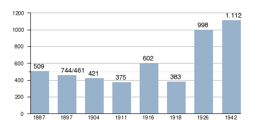
Population of the Kronau district

history
1920–1930 a German National Circle named Friedrich Heckert was founded . During the times of famine, 55 people died from 1921 to 1922 and 12 people died of starvation during the Holodomor from 1932 to 1933. Between 1929 and 1941, 71 residents were deported by the Soviets . On November 15, 1941, the General District of Nikolayev was formed in the Reichskommissariat Ukraine from the Oblasts Kirovograd and Nikolajew . That was administered by the General Commissioner in Nikolayev . In this district was also the district area Alexanderstadt founded on the same day , which in turn contained the Rajon Kronau founded on April 1, 1942 .
On March 28, 1944, Kronau and all other settlements were taken by the Red Army .
Web links
Individual evidence
- ↑ Stumpp, Karl. Report on the Kronau-Orloff area (Orloff now Marienburg). Reports from the Georg Leibbrandt Collection. - Berlin: Publication Office East - 1943.
- ↑ http://www.grhs.org/vr/Nikolajew/kronau_nikolajew.htm
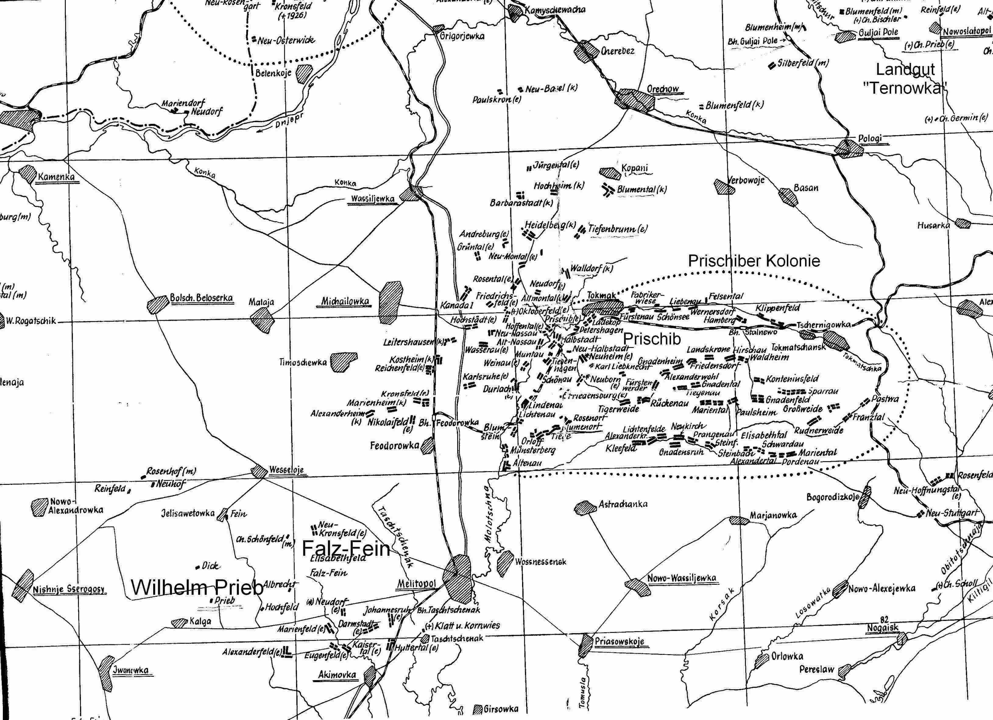
- ↑ http://www.stammbaum-familie-prieb.de/PrischiberKolonie.jpg
- ↑ a b http://www.territorial.de/ukra/nikolaje/nikol.htm
- ↑ http://www.territorial.de/ukra/nikolaje/alexanst.htm