Konkiep
|
Konkiep Konkiep Rivier |
||
|
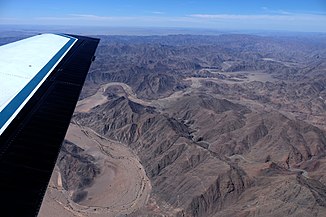
Konkiep at 27 ° 52'17 ″ S 017 ° 16′08 ″ E, viewing direction southeast
|
||
| Data | ||
| location |
|
|
| River system | Orange | |
| Drain over | Fish river → Orange River → Atlantic | |
| source |
Black border 25 ° 33 ′ 52 ″ S , 16 ° 46 ′ 20 ″ O |
|
| muzzle | in the fish river coordinates: 28 ° 3 ′ 33 ″ S , 17 ° 20 ′ 2 ″ E 28 ° 3 ′ 33 ″ S , 17 ° 20 ′ 2 ″ E
|
|
The Konkiep is an ephemeral dry river ( Rivier ) in the southwest of Namibia . It rises in the Hardap region on the Schwarzrand and flows into the Fish River in the ǁKaras region . A tributary of the Konkiep is the Gurieb , which rises on the plateau of the Schwarzrand and flows into the Konkiep at 27 ° 00'52 "N 017 ° 17'25" E. The picture on the right shows the Konkiep 22 km as the crow flies before the confluence with the Fish River.
literature
- Mary Seely, Kathryn M. Jacobson, Peter J. Jacobson: Ephemeral Rivers and Their Catchments - Sustaining People and Development in Western Namibia . Desert Research Foundation of Namibia, 1995, ISBN 978-99916-709-4-2
Web links
Commons : Konkiep River - collection of images, videos and audio files
