
Konowka
| Konowka | |||
| Коновка | |||

|
|
||
| Basic data | |||
|---|---|---|---|
| Oblast : | Chernivtsi Oblast | ||
| Rajon : | Kelmenzi district | ||
| Height : | 200 m | ||
| Area : | Information is missing | ||
| Residents : | 630 (2001) | ||
| Postcodes : | 60112 | ||
| Area code : | +380 3732 | ||
| Geographic location : | 48 ° 31 ' N , 26 ° 43' E | ||
| KOATUU : | 7322085401 | ||
| Administrative structure : | 1 village | ||
| Address: | вул. Центральна буд. 15 60112 с. Коновка |
||
| Website : | City council website | ||
| Statistical information | |||
|
|||


Konowka ( Ukrainian and Russian Коновка , Romanian Cofa ) is a village in the northeast of the Ukrainian Oblast Chernivtsi with about 630 inhabitants (2001).
The village is the only locality of the district council of the same name in the north of Kelmenzi district .
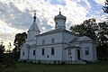
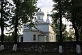
The village is located at an altitude of 200 m 2 km west of the village of Lenkivtsi on the bank of the Dniester , which here forms the border with the Khmelnytskyi Oblast . The village is located about 90 km northeast of the Chernivtsi Oblast center . In 1900 the Orthodox Church of the Assumption of the Virgin Mary was built in the village.
The territorial road T – 26–17 runs north-east of Konowka , via which the Kelmenzi district center can be reached after 14 km in a south-easterly direction. The nearest train station is in neighboring Lenkiwzi on the Kelmenzi – Kalinkawitschy railway line .
Side view of the Assumption Church
Orthodox Church of the Assumption

Parish hall

Community library


Individual evidence
- ↑ Local website on the official website of the Verkhovna Rada ; accessed on May 22, 2019 (Ukrainian)
- ^ Website of the district council on the official website of the Verkhovna Rada; accessed on May 22, 2019 (Ukrainian)