
Kouhu
|
Kouhu 口 湖鄉 |
|||
.svg) Location Kouhus in Yunlin County |
|||
| State : |
|
||
| County : | Yunlin | ||
| Coordinates : | 23 ° 35 ' N , 120 ° 10' E | ||
| Area : | 80.4612 km² | ||
| Residents : | 27,410 (Sep 2018) | ||
| Population density : | 341 inhabitants per km² | ||
| Time zone : | UTC + 8 (Chungyuan time) | ||
| Telephone code : | (+886) (0) 5 | ||
| Postal code : | 653 | ||
| ISO 3166-2 : | TW-YUN | ||
| Community type : | Rural community (鄉, Xiāng) | ||
| Structure : | 21 villages (村, Cūn ) | ||
| Mayor : | Lin Zheling ( 林哲凌 ) ( DPP ) | ||
| Website : | |||
|
|||

Kouhu ( Chinese 口 湖鄉 , Pinyin Kǒuhú Xiāng ) is a rural community in Yunlin County in the Republic of China, Taiwan .
location
Kouhu is located on the west coast of Taiwan in the southwest corner of Yunlin County. The neighboring communities are Sihu in the north, Shuilin in the west and Dongshi in the neighboring district of Chiayi to the south . The southern boundary of the municipality is the Beigang (Peikang) or Beigangxi ( 北港溪 , Chinese 溪 , Pinyin Xī - "small river"). The community forms a flat coastal plain. Geologically, Kouhu consists of alluvial land that arose in the Holocene .
Kouhu is north of the Tropic of Cancer and thus in the subtropics. The climate is warm and rainy. The average temperatures vary between 16 and 18 ° C in January and 28 to 30 ° C in July / August (data from 1993 to 2004). Annual precipitation is around 1350 mm, with more than half recorded from June to August. The annual precipitation varies considerably from year to year (in the period 1994 to 2005 between about 800 mm and more than 2000 mm). The tidal range on the coast is up to about 3.5 meters. The community off the coast to the southwest is about 17.2 km² large Waisanding sandbank (-S 傘 頂 洲 , English sometimes simply Barrier Island ). The sandbar only rises up from the sea and is unpopulated. Their area is not included in the community area and is not even shown on many maps (e.g. Google Maps ). Their boundaries are constantly changing through erosion and sedimentation. Administratively it is assigned to the municipality of Kouhu.
history
In historical times, the coastline changed significantly due to floods and siltation. Originally, Pingpu (members of the indigenous peoples of Taiwan living in the plains ) lived in the area. These were gradually displaced or assimilated by the Han Chinese , who had come from the mainland in large numbers at least since the reign of Qianlong . A fortified settlement Jianshan ( Chinese 尖山 堡 , Pinyin Jiānshān bǎo ) was established. After the district of Yunlin was established in 1887, towards the end of the Qing rule over Taiwan, the area of Kouhu was administratively assigned to it. The current municipal boundaries were established in 1920, during the Japanese rule over Taiwan . With the reorganization of Taiwan's administration in 1950 at the time of the Republic of China, the place became a rural community in the newly established Yunlin County. The name 'Kouhu' ( 口湖 ) literally means “estuary waters” ( 口 , Kǒu - “mouth”, 湖 , hú - “lake”) and is derived on the one hand from the river mouth with the lagoon and on the other hand from the one here often existing fish ponds.
population
As in all communities on Taiwan's west coast, the proportion of indigenous peoples in the resident population of Kouhu is low. At the end of 2017 it was around 0.2% (fewer than 100 people). There were 41 temples (38 Taoist , 3 Buddhist ) in the Kouhu parish in 2016 .
Administrative division
| Administrative division of Kouhus |
|
a
b
c
d
e
f
G
H
i
j
k
l
m
n
O
p
q
r
s
t
u
a: Xialun 下 崙 村
b: Lunzuhong 崙 中 村
c: Boy with 埔 北 村
d: Lundong 崙 東村
e: Qinghan 青 蚶 村
f: Dinghu 頂 湖村
g: Bunan 埔 南村
h: Gangxi 港 西村
i: Hudong 湖 東村
j: Kouhu 口 湖村
k: Gangdong 港 東村
l: Xiecuo 謝 厝村
m: Taizi 台子 村
n: Chenglong 成龍 村
o: Heliao 蚵 寮村
p: Guogang 過 港 村
q: Wubei 梧 北 村
r: Hukou 湖口 村
s: Wunan 梧 南村
t: Shuijing 水井 村
u: Houcuo 後 厝村
Waisanding sandbar
外 傘 頂 洲 |
.svg)
Kouhu is divided into 21 villages:
- Hudong 湖 東村
- Kouhu 口 湖村
- Dinghu 頂 湖村
- Boy with 埔 北 村
- Bunan 埔 南村
- Xiecuo 謝 厝村
- Heliao 蚵 寮村
- Xialun 下 崙 村
- Lunzuhong 崙 中 村
- Lundong 崙 東村
- Qinghan 青 蚶 村
- Gangdong 港 東村
- Gangxi 港 西村
- Taizi 台子 村
- Chenglong 成龍 村
- Hukou 湖口 村
- Shuijing 水井 村
- Houcuo 後 厝村
- Wunan 梧 南村
- Wubei 梧 北 村
- Guogang 過 港 村
traffic
Provincial Road 61 ("West Coast Expressway", Western Coastal Highway ) runs parallel to Provincial Road 17 in a north-south direction through Kouhu. District road 164 branches off about in the middle and leads away from the coast into the interior.
Agricultural products
Around 3500 hectares are used as arable land. The most important in quantitative terms is the cultivation of rice, sweet potatoes , feed grain, sugar cane , cabbage and peanuts. Pig breeding is carried out on a larger scale. Kouhu is a major aquaculture and fishing center. Here are mullet , sea bream , dog tongues , decapods , Japanese clams and eels bred or caught. A specialty of Kouhus are the red algae of the genus Graciliaria “grown” on the coast . After cooking, the intensely dark green algae are marketed as “sea vegetables ” ( 海 的 蔬菜 , or 巧 味 芽 , “tasty bud”).
Originally, oyster farming also played a larger role. However, in 1991, larger stretches of coast were reserved for offshore industrial needs, so that oyster farming and fishing were only possible to a very limited extent here. After no new industrial settlements took place there between 2004 and 2015, there were demands to reopen the affected coastal areas for oyster fishing.
Attractions
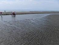
Waisanding sandbar

A tourist destination is the elongated Waisanding sandbank off the coast, which can be reached by excursion boats. The sandbar emerged from alluvial sediments of rivers Zhuoshui River ( 濁水溪 ) Beigang and Hsiluo ( 西螺溪 ). Between around 1790 and 1911, the Zhuoshui River (Taiwan's largest river system) flowed significantly further south than it does today, so sediment inputs from this river contributed to the sandbar's growth for more than a century. As part of a plan to contain flooding, in 1911 the course of the river and the mouth of the Zhuoshui were relocated about 14 kilometers to the north, which resulted in the northern inflow of sediment to the sandbar largely drying up. As a result, the sandbank moved south at a speed of around 250 meters per year from 1932 to 1952. In the decade 1973 to 1984, even 500 meters per year were measured at the southern end. Increased sediment input from the rivers after major earthquakes (more recently the Jiji earthquake in 1999) also influenced the change in shape of the sandbank. Overall, there has been significant erosion of the sandbank since 1911. Scientists have therefore heard suggestions that artificial barriers, e.g. B. Breakwaters should be built and the sandbar should be planted to stop or slow erosion. The English name Barrier Island refers to the effect of the sandbank as a coastal protection barrier. In the event of their disappearance, also against the background of rising sea levels around the world, serious consequences are feared for the coastal sections behind them (erosion, floods, salinization, etc.).
In April 2016, Taiwan established a 763 km² protection zone for the Chinese white dolphin north of the Waisanding sandbank off the coast of Yunlin and Miaoli .
Chenglong wetland
The 171 hectare Chenglong Wetland ( 成龍 濕 地 ) was created after agricultural land was repeatedly hit by typhoon-induced floods (particularly in August 1986 and July 1996). After that, the land was left to its own devices and gradually turned into a salt marsh, which became a refuge for plants, fish and birds and eventually received protection status.
Waisanding sandbar
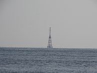
Lighthouse on the sandbar
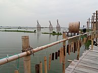
Chenglong wetland
.jpg)

.jpg)
Web links
Individual evidence
- ↑ a b 口 湖鄉 志 >> 第 01 篇 - 地理 篇 ("Kouhu Municipality: Part 01: Geography"). Kouhu website, accessed October 28, 2018 (Chinese).
- ↑ 歷史 沿革 ("Historical Development"). Kouhu website, accessed October 28, 2018 (Chinese).
- ↑ 原住民 戶數 及 人數 Households and Persons of Indigenous People. (xls) Ministry of Interior of Taiwan, accessed October 4, 2018 (Chinese, English).
- ↑ a b 統計 資料 ("Statistics"). Kouhu website, accessed October 27, 2018 (Chinese).
- ↑ 地理 環境 ("Geographical Environment"). Kouhu website, accessed October 27, 2018 (Chinese).
- ↑ 春夏 秋冬 遊 口湖 - 口湖 特產 (Spring, Summer, Autumn and Winter Tour through Kouhu - Kouhu specialties). Kouhu website, accessed October 28, 2018 (Chinese).
- ↑ 口湖 特產 - 龍鬚 菜 (Kouhu specialties: seaweed). Taiwan Ministry of Education, accessed October 28, 2018 (Chinese).
- ↑ 龍鬚 菜 (海 的 蔬菜) "Seaweed dishes (sea vegetables)". Kouhu website, accessed October 28, 2018 (Chinese).
- ↑ Chen Wei-han: Yunlin commissioner pleads oyster farmers' case. October 19, 2015, accessed October 27, 2018 .
- ↑ Waisanding Sand Bar. Southwest Coast National Landscape Area, December 21, 2017, accessed October 28, 2018 .
- ↑ Eason Hong, W. Brian Dade, Yet-Chung Chang and Shun-Yu Chan: Geomorphic Evolution of a Barrier Island Reflects the History of Natural Sediment Supply and Human Intervention in Taiwan . In: Journal of Coastal Research . tape 26 , no. 1 , January 2010, p. 53-58 , doi : 10.21121 / 08-1008.1 , JSTOR : 27752785 (English).
- ^ Rapid erosion a threat to Waisanding Sandbar. Taipei Times, June 4, 2007, accessed October 28, 2018 .
- ↑ Wen-Juinn Chen: Impact of Sea-Level Rise on Chiayi Coast . In: Chinese-German Joint Symposium on Hydraulic and Ocean Engineering . Darmstadt October 24, 2008, p. 289–295 (English, PDF ).
- ↑ Ulrich Karlowski: Taiwan establishes first sanctuary for Chinese white dolphins. Society for the Rescue of the Dolphins, April 16, 2014, accessed October 28, 2018 .
- ↑ 成龍 暫定 重要 濕 地 (Chenglong temporarily important wetland). Retrieved October 29, 2018 (Chinese).
