
Dongshi (Chiayi)
|
Dongshi 東 石 鄉 |
|||
.svg) Location of Dongshi in Chiayi County |
|||
| State : |
|
||
| County : | Chiayi | ||
| Coordinates : | 23 ° 28 ' N , 120 ° 11' E | ||
| Area : | 81.582 km² | ||
| Residents : | 24,194 (Dec 2019) | ||
| Population density : | 297 inhabitants per km² | ||
| Time zone : | UTC + 8 (Chungyuan time) | ||
| Telephone code : | (+886) (0) 5 | ||
| Postal code : | 614 | ||
| ISO 3166-2 : | TW-CYQ | ||
| Community type : | Rural community ( 鄉 , Xiang ) | ||
| Structure : | 23 villages ( 村 , Cūn ) | ||
| Website : | |||
|
|||

Dongshi ( Chinese 東 石 鄉 , Pinyin Dōngshí Xiāng ) is a rural community ( 鄉 , Xiang ) in Chiayi County in the Republic of China on Taiwan .
location
Dongshi is located in western Chiayi County on the Taiwan Strait coast and on the western edge of the Jianan Plain . The maximum north-south extension is approximately 12.9 km and the maximum east-west extension is approximately 10 km. The coastline is approximately 14 km. The terrain is very flat and there are three larger rivers that flow into the Taiwan Strait - in the north the Beigangxi ( 北港溪 ), which also forms the border with the northern district of Yunlin , and a little further south the Liujiao paishui ( 六 腳 排水 , Liù jiǎo páishuǐ ), a drainage canal , and further south the Puzixi ( 朴子溪 , Pǔzixī ). The neighboring communities are Kouhu in the north and Shuilin in the northeast (both in Yunlin County), as well as Liujiao and Puzi in the east and Budai in the southeast / south.
The annual mean temperature is 22.5 ° C, the average annual precipitation is around 1707 millimeters and the average annual sunshine duration is around 2064 hours.
history
The first Han Chinese immigrants came from the year 1661 Koxinga and the reign Kangxi in the area of Dongshi. These immigrants came from what is now Hui'an County in Fujian Province. During the Japanese colonial period in Taiwan (1895-1945), a major administrative reform took place in 1920, which set up the 'village of Dongshi' ( 東 石 庄 , Dōngshí zhuāng ) in Tainan Prefecture . In 1945/46, after the Republic of China took over the island of Taiwan, the village became the rural community ( 鄉 , Xiang ) Dongshi in Tainan County . In 1950 the northern part of Tainan County was separated and part of it was organized as a separate Chiayi County. Since then, Dongshi has been a community in Chiayi County.
population
With a population of around 24,000 (2020), Dongshi is one of the medium-sized communities in Chiayi County. At the end of 2018, 62 people (0.3%) belonged to the indigenous peoples of Taiwan.
| Outline of Dongshi |

|
Administrative division
Dongshi is divided into 23 villages ( 村 , Cūn ):
1 Aogu ( 鰲 鼓 村 )
2 Gangkou ( 港口 村 )
3 Xixia ( 溪 下 村 )
4 Fulai ( 副 瀨 村 )
5 Longgang ( 龍港 村 )
6 Xiayi ( 下 揖 村 )
7 Dingyi ( 頂 揖 村 )
8 Xingcuo ( 型 厝村 )
9 Wengang ( 塭 港 村 )
10 Yuanshu ( 猿 樹村 )
11 Sanjia ( 三 家村 )
12 Haipu ( 海 埔村 )
13 Weitan ( 圍 潭村 )
14 Niaosong ( 蔦 松 村 )
15 Dongshi ( 東 石村 )
16 Yongtun ( 永 屯村 )
17 Zhouzai ( 洲 仔 村 )
18 Gangqi ( 港墘 村 )
19 Wenzai ( 塭 仔 村 )
20 Wangliao ( 網 寮村 )
21 Donglun ( 東 崙 村 )
22 Zhangtan ( 掌 潭村 )
23 Xilun ( 西崙 村 )
economy
The economic structure of Donghi is largely determined by agriculture. In the decades after the Second World War, mainly rice and sugar cane were cultivated. Vegetable asparagus was added from the 1950s , and various types of millet from the 1980s . In recent times agriculture has diversified more and more and crops such as tomatoes, mushroom cultures ( brown herb mushroom ), cucumbers and, on ornamental flowers, the prairie bellflower ( Eustoma russellianum ) have been grown. Due to the rural exodus and the associated labor shortage, as well as the sometimes increasing salinization of the soil, larger proportions of agricultural land were converted into fish ponds for aquaculture over time. The fishing industry in Dongshi can be divided into inland aquaculture, offshore - oyster farming and coastal fisheries. The total area of the more than 5000 fish ponds amounts to about 2140 hectares. The main farms are tilapia , milk fish , perch fish , Japanese clams and shrimp .
traffic
Dongshi is well developed in terms of traffic. The main traffic artery is the provincial expressway 61, which runs parallel to the coast from north to south. In the north, provincial road 17 initially runs parallel to this, which later turns to the east and a little further inland also runs in a north-south direction. There are also a few larger district roads, which essentially run in an east-west direction (No. 166, 168, 170).
particularities
The small fishing port and the fishing mooring ( 漁人 碼頭 , yúrén mǎtóu ) in the village of Dongshi are a popular destination for tourists. In the village of Aogu there is a small nature reserve established in 2009, the Aogu Wetland ( 鰲 鼓 溼 地 , Áogǔ shīdì ). Above all, rare water birds can be observed here. There are also several older temples in Dongshi , such as the Daoist Xiantian Temple ( 先 天宮 , Xiāntiān gōng ) in the village of Yuanshu, the Buddhist Fuling Temple ( 福 靈宮 , Fúlíng gōng ) in the village of Sanjia, where Guanyin is venerated, and the 1879 built Fu'an Temple ( 富 安 宮 , Fù'ān gōng ), a temple of Chinese folk belief in the village of Fulai. The temple also commemorates the Japanese policeman Morikawa Seijiro (森川 清 治郎) who was stationed in Dongshi and who committed suicide in 1902 in protest against the harsh tax policies of the Japanese administration. In the temple he was worshiped as Yiaigong ( 義 愛 公 , Yìài gōng - "Lord of justice and mildness") in the form of a small statue. The shrine is also visited by police officers from Japan at irregular intervals.
![]()
![]()
![]()
![]()
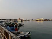 Fishing port
 Oyster fishing in Dongshi
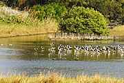 Aogu wetland
 Xiantian temple

.jpg)


Web links
Individual evidence
- ↑ 地理 環境 (Geographic Area). Dongshi website, accessed March 13, 2020 (Traditional Chinese).
- ↑ 歷史 沿革 (history). Dongshi website, accessed March 13, 2020 (Traditional Chinese).
- ↑ 原住民 戶數 及 人數 Households and Persons of Indigenous People. (xls) Taiwan Ministry of the Interior, accessed August 4, 2018 (Chinese, English).
- ↑ 村庄 巡禮 (Tour of the Villages). Dongshi website, accessed March 14, 2020 (Traditional Chinese).
- ↑ 產業 文化 (economic structure). Dongshi website, accessed March 13, 2020 (Traditional Chinese).
- ↑ Aogu Wetlands. Culture and Tourism Authority of Chiayi County, November 9, 2017, accessed on March 14, 2020 (Chinese (traditional)).
- ↑ Dongshi Xiantian Temple. Southwest Coast National Landscape Area, November 3, 2016, accessed March 14, 2020 (Traditional Chinese).
- ↑ 福 靈宮 鐵嘴 將軍. Cultural and Tourism Authority of Chiayi County, November 8, 2017, accessed on March 14, 2020 (Chinese (traditional)).
- ↑ Min-Chia Young: Your Highness, Mr. Policeman: the Taiwanese perception of the policeman during the Japanese Colonial Rule . Ed .: Conference reports of the Asian Conference on Ethics, Religion and Philosophy, ACERP2017. Kobe , Japan 2017 (English, pdf ).
- ↑ 富 安 宮 奉 義 愛 公 紀念日 巡查 森川. China Daily News, August 28, 2015, accessed March 14, 2020 (Traditional Chinese).
- ↑ 富 安 宮 奉 義 愛 公 紀念日 巡查 森川. China Daily News, August 28, 2015, accessed March 14, 2020 (Traditional Chinese).
- ↑ 日 警 祭拜 警察 神. Apple Daily, March 11, 2011, accessed March 14, 2020 (Traditional Chinese).
