Zhuqi
|
Zhuqi 竹崎 鄉 |
||
 Location of Zhuqi in Chiayi County |
||
| State : |
|
|
| County : | Chiayi | |
| Coordinates : | 23 ° 30 ' N , 120 ° 36' E | |
| Area : | 162.2256 km² | |
| Residents : | 35,331 (July 2019) | |
| Population density : | 218 inhabitants per km² | |
| Time zone : | UTC + 8 (Chungyuan time) | |
| Telephone code : | (+886) (0) 5 | |
| Postal code : | 604 | |
| ISO 3166-2 : | TW-CYQ | |
| Community type : | Rural community ( 鄉 , Xiang ) | |
| Structure : | 24 villages ( 村 , Cūn ) | |
| Website : | ||
|
|
||
Zhuqi ( Chinese 竹崎鄉 , Pinyin Zhuqi Xiang , PEH OE jī Tek Kia hiong ) is a rural municipality ( 鄉 , Xiang ) in Chiayi County the Republic of China on Taiwan .
location
Zhuqi is located in the east of Chiayi County. The municipality has an elongated shape with a maximum east-west extension of 23 kilometers, and a north-south extension between 4 and 9 kilometers. The eastern and northern parts are occupied by mountainous areas, while the western part is part of the Jianan Plain . The neighboring communities are Meishan in the north, Minxiong in the west, the eastern district of the city of Chiayi in the southwest, Fanlu in the south, and Alishan in the east.
history
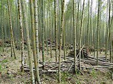
An older name of Zhuqi is Zhutouqi ( 竹 頭 崎 , Zhútóu qí , Pe̍h-ōe-jī Tik-thâu-kiā ). The name is derived from the abundant stocks of bamboo that have been used by humans for a long time. The bamboo was felled and stumps remained, the "bamboo heads" ( 竹 頭 , Zhútóu - "bamboo head"). The syllable qí / kiā means "steep" in Taiwanese. Zhutouqi was known as the mountainous area where bamboo was felled in abundance. During the Qing period, the Zhuqi area was initially administratively assigned to Zhuluo County ( 諸 羅 縣 ). Under Japanese rule , the administrative structures were reorganized and from 1920 Zhuqi was a 'village' ( 庄 , Zhuāng ) in Tainan Prefecture . After Taiwan was taken over by the Republic of China in 1945, Zhuqi became a 'rural community' ( 鄉 , Xiang ) in January 1946 , initially in Tainan County and from October 25, 1950 in the newly established Chiayi County.
population
At the end of 2017, 112 people (around 0.3%) belonged to the indigenous peoples.
| Outline of Zhuqi |

|
administration
Zhuqi is divided into 24 villages ( 村 , Cūn ):
1 Shiye ( 獅 埜村 )
2 Shakeng ( 沙坑 村 )
3 Kengtou ( 坑 頭村 )
4 Heping ( 和平 村 )
5 Yiren ( 義 仁 村 )
6 Yihe ( 義 和村 )
7 Wanqiao ( 灣 橋村 )
8 Luman ( 鹿 滿 村 )
9 Ziyun ( 紫雲 村 )
10 Yilong ( 義隆 村 )
11 Zhuqi ( 竹崎 村 )
12 Fujin ( 復 金 村 )
13 Longshan ( 龍山村 )
14 Tangxing ( 塘 興村 )
15 Neipu ( 內 埔村 )
16 Shengping ( 昇平 村 )
17 Taoyuan ( 桃源村 )
18 Baiqi ( 白 杞 村 )
19 Wenfeng ( 文峯 村 )
20 Jinshi ( 金獅 村 )
21 Duanxu ( 緞 繻 村 )
22 Renshou ( 仁壽 村 )
23 Guanghua ( 光華 村 )
24 Zhonghe ( 中和村 )
Agriculture
Local farm products are gourd , ginger and bamboo shoots in the plains . Daylilies (as vegetables), cabbage , garlic , taro , kidney beans , moso bamboo , etc. are grown in the higher-lying, colder regions . Be on fruits pineapple , longan , lychee , persimmon , dragon fruit , avocado , guava , pear , citrus and mountain tea ( Gaoshan tea ) cultivated. The tea-growing areas cover around 400 hectares and are located in Guanghua, Zhonge, Jinshi and Renshou.
traffic
The highway (national road) 3 runs through a small western section (on the city limits of Chiayis) . In the west, Zhuqi is crossed by Provincial Road 3 in a north-south direction. Provincial road 18 runs right on the eastern edge of Zhuqi, also largely in a north-south direction. The most important east-west connection is the county road 166 and further south, only partially in the area of Zhuqi, the county road 159 or 159A (159 甲).
The Alishan Forest Railway runs through Zhuqi from west to east. It was built to transport timber from 1912 during the Japanese rule and is now used for tourist purposes.
tourism
A tourist magnet is the aforementioned Alishan Forest Railway, which has several stops in the Zhuqi area. The main attraction is nature, e.g. B. with the Guanyin waterfall ( 觀音 瀑 , Guānyīn pù , ) or the Yuntan waterfall ( 雲 潭 瀑 , Yúntán pù , ).
![]()
![]()
Web links
Individual evidence
- ↑ 竹 頭 崎. twblg.dict.edu.tw/holodict_new/ (online dictionary of Taiwanese Minnan), accessed August 25, 2019 (Chinese (Traditional)).
- ↑ 服務 白皮書. Zhuqi's website, accessed August 25, 2019 (Traditional Chinese).
- ↑ 原住民 戶數 及 人數 Households and Persons of Indigenous People. (xls) Taiwan Ministry of the Interior, accessed May 5, 2018 (Chinese, English).
- ↑ 地方 經濟 ("Local Economy"). Zhuqi's website, accessed August 25, 2019 (Traditional Chinese).
- ^ Guanyin Waterfall Scenic Area. Alishan National Landscape Area, May 23, 2017, accessed August 27, 2019 .
- ↑ Yuntan Waterfall. Alishan National Landscape Area, May 23, 2017, accessed August 27, 2019 .


