
Dapu (Chiayi)
|
Dapu 大埔 鄉 |
|||
.svg) Location Dapus in Chiayi County |
|||
| State : |
|
||
| County : | Chiayi | ||
| Coordinates : | 23 ° 18 ' N , 120 ° 36' E | ||
| Height : | ~ 227 - 1241 m | ||
| Area : | 173.2472 km² | ||
| Residents : | 4,588 (Sep 2018) | ||
| Population density : | 26 inhabitants per km² | ||
| Time zone : | UTC + 8 (Chungyuan time) | ||
| Telephone code : | (+886) (0) 5 | ||
| Postal code : | 607 | ||
| ISO 3166-2 : | TW-CYQ | ||
| Community type : | Rural community ( 鄉 , Xiang ) | ||
| Structure : | 5 villages ( 村 , Cūn ) | ||
| Mayor : | Huang Guoming ( 黃國明 ) ( KMT ) | ||
| Website : | |||
|
|||

Dapu ( Chinese 大埔鄉 , Pinyin Dàpǔ Xiang ) is a rural municipality ( 鄉 , Xiang ) in Chiayi County the Republic of China on Taiwan .
location
Dapu is located in the southeast corner of Chiayi County in the southwest of the Alishan Mountains . The neighboring communities are Zhongpu and Fanlu in the north, Alishan and Namaxia (in Kaohsiung ) in the east, Nanhua and Nanxi in the south, and Dongshan and Baihe in the west (the latter four all in Tainan ). The terrain is characterized by steep, forested mountains with narrowly cut valleys. The highest point is the 1241 meter high Dadongshan ( ⼤ 棟 ⼭ ) on the border with Baihe. The water level of the Zengwen Reservoir , presumably the lowest point, is a maximum of about 227 meters above sea level.
history
The native people of the area are indigenous Taiwanese ethnic groups (Austronesians). After Taiwan was taken over by the Chinese Empire of the Qing Dynasty , the area belonged to Zhuluo County ( 諸 羅 縣 ) from 1683 . In 1787, during Qianlong's reign , Zhuluo County was renamed Chiayi County. After the annexation of Taiwan by Japan in 1895, Dapu was initially subject to various administrative jurisdictions and from 1920 belonged to Tainan Prefecture . After Taiwan became part of the Republic of China in 1945 , an administrative reorganization followed and Dapu became a rural community ( 鄉 , Xiang ) in the newly formed district of Chiayi in 1950.
population
With around 4600 inhabitants, Dapu is the smallest municipality in the Chiayi County. At the end of 2017, 47 people (around 1%) belonged to the indigenous peoples.
administration
Dapu is divided into 5 villages ( 村 , Cūn ): Dapu ( 大埔 村 ), Jiadong ( 茄 苳 村 ), Xixing ( 西 興村 ), Heping ( 和平 村 ) and Yongle ( 永樂 村 ).
| Outline of Dapu |

|
Agriculture
Only about 5.2 percent of the land area is used for agriculture. A significant part of the areas previously used for agriculture was flooded by the Zengwen reservoir in the 1970s. More than 90% of the total area of Dapu are state-owned and are mostly forests that enjoy at least some protection status.
traffic
The only major road is Provincial Road 3, which crosses the municipality in a north-south direction on the east side of the Zengwen Reservoir.
Zengwen Reservoir
About 17 km² area (9.8% of the area of Dapu) is taken up by the Zengwen Reservoir ( 曾文 壩 ), which was created after the completion of the associated Zengwen Dam for the damming of the river of the same name in the 1970s. With a volume of 491,590 m³, the lake is Taiwan's largest reservoir. It is primarily used for water supply (including agriculture), energy generation and flood control. The reservoir is also an important tourist destination.
tourism
Tourism is an essential economic factor in Dapu. In addition to the reservoir, there are other tourist attractions. These include natural attractions such as the holiday resort Pinglin ( 坪林 風景區 , Pinglin Resort ) in the village of Jiadong, the Hu Bin Park ( 湖濱 公園 ), the Qingren Park ( 情人 公園 - "Lovers Park", English Valentine Park ), the Fengchui mountain park ( 風吹 嶺 - "Windy Ridge"), etc.
Before the dam began to be flooded, the remains from around 7000 graves in the area of the future reservoir were transferred to the newly built Seven Pagoda Temple ( 寺 七 寶塔 ), which became a place of religious visiting. The Beiji Temple ( 北極 殿 - "Arctic Temple") , built in 1760, is also worth seeing .
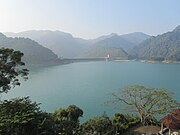
Zengwen Reservoir
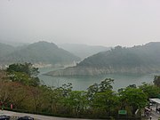
different view of the reservoir


Web links
Individual evidence
- ↑ Source: Openstreetmap
- ↑ Taiwan mulls measures to increase water supply by 2031. Overseas Community Affairs Council, accessed December 8, 2018 .
- ↑ a b 行政 區域 歸屬 沿革 ("administrative area allocation"). Dapu website, accessed December 7, 2018 (Chinese).
- ↑ 原住民 戶數 及 人數 Households and Persons of Indigenous People. (xls) Taiwan Ministry of the Interior, accessed May 5, 2018 (Chinese, English).
- ↑ 地理 環境 ("Geographical Environment"). Dapu website, accessed December 7, 2018 (Chinese).
- ↑ reservoirs, dams and weirs of Taiwan. June 26, 2013, Retrieved December 8, 2018 (Chinese).
- ↑ 曾文 水庫 ("Zengwen Reservoir"). Taiwan Ministry of Economic Affairs, accessed December 8, 2018 (Chinese).
- ↑ Explore Chiayi. Chiayi County Culture and Tourism Authority, accessed December 8, 2018 (Chinese).
