
Baihe (Tainan)
|
Baihe 白河 區 |
|||
.svg) Location of Baihe in Tainan |
|||
| State : |
|
||
| Coordinates : | 23 ° 21 ' N , 120 ° 25' E | ||
| Area : | 126.4046 km² | ||
| Residents : | 28,175 (Sep. 2018) | ||
| Population density : | 223 inhabitants per km² | ||
| Time zone : | UTC + 8 (Chungyuan time) | ||
| Telephone code : | (+886) (0) 6 | ||
| Postal code : | 732 | ||
| ISO 3166-2 : | TW-TNN | ||
| Community type : | Municipality of Tainan | ||
| Structure : | 21 districts ( 里 , Lǐ ) | ||
| Website : | |||
|
|||

Baihe ( Chinese 白河 區 , Pinyin Báihé Qū ) is a district of the government- immediate city of Tainan in the southwest of the Republic of China in Taiwan .
Description, location and climate
Baihe is located in the Jianan Plain on the northeastern border of the urban area of Tainan, adjacent to the neighboring district of Chiayi . With about 126 km² it is the second largest district in Tainan. In terms of population, however, it was only 18th in 2018 (out of 37). The neighboring districts are Houbi in the west and Dongshan in the south. In Chiayi County, the Shuishang , Zhongpu, and Dapu communities border on the north and west. The climate is subtropical and warm and characterized by the monsoons .
history
The first permanent settlement of Han Chinese took place during the reign of Emperor Qianlong . The original name of the place was 店 仔 口 , Diàn zǐkǒu jiē - "gateway to the shop", because there was a small shop here. Eventually a kind of marketplace developed and the location was named Baihe ( 白河 - “White River”) after the local flowing water during the Japanese colonial era . After 1945, Baihe became a township in the newly established Tainan County . On December 25, 2010, the entire Tainan County was integrated into Tainan City and the former county councils were given the status of municipalities. The municipality of Baihe ( 白 河鎮 , Báihé Zhèn ) became the district of Baihe ( 白河 區 , Báihé Qū ).
population
In December 2017, 58 of the 28,520 inhabitants at that time belonged to the indigenous peoples. At 0.2%, the proportion was well below the Taiwanese average. The population has been slowly declining for decades due to emigration and aging. In 1950 Baihe had 30,201 inhabitants, in 1981 the previous high was reached with 47,664 and since then the population has decreased almost continuously to around 28,200 in 2018.
administration
On November 10, 2017, the city administration announced a new division of the city district into 21 districts ( 里 , Lǐ ), which was implemented in two phases on January 29 and April 30, 2018.
| Outline of Baihe |
|
|


1 Guanling ( 關嶺 里 )
2 Xiancao ( 仙草 里 )
3 Hushan ( 虎山 里 )
4 Dalin ( 大林 里 )
5 Hedong ( 河東 里 )
6 Liuxi ( 六 溪 里 )
7 Dazhu ( 大竹 里 )
8 Zhaofeng ( 詔 豐里 )
9 Guanglian ( 廣 蓮 里 )
10 Baihe ( 白河 里 )
11 Zhuangnei ( 庄內 里 )
12 Waijiao ( 外角 里 )
13 Yong'an ( 永安 里 )
14 Biaontou ( 汴 頭里 )
15 Xiuyou ( 秀 祐 里 )
16 Neijiao ( 內角 里 )
17 Qinei ( 崎 內 里 )
18 Machouhu ( 馬 稠 後 里 )
19 Zhumen ( 竹 門 里 )
20 Kantou ( 崁 頭里 )
21 Shengan ( 昇 安 里 )
traffic

Baihe is crossed in a north-south direction by the national road 3 (motorway). District road 172 runs in east-west direction and district roads 165 (in the west of Baihe) and 175 (in the east) run from south-south-west to north-northeast. There is no direct rail link.
Agriculture
Baihe is known nationwide for its lotus cultivation. About two-thirds of Taiwan's total lotus acreage is found in Baihe. Different parts of the lotus plant are used. In summer, the lotus seeds are extracted, peeled and dried in laborious manual labor. The lotus seeds are used in various dishes and the seeds (germs) play a role in traditional Chinese medicine . One hectare of cultivated land typically yields two to three tons of lotus seeds. Lotus roots harvested in winter are used to make lotus flour, which is used in various types of desserts, soups, and cosmetic products. Other products include Nanliao - mandarins ( Ponkans , available September to mid-December).
Attractions
There are a number of attractions in Baihe. This includes the four-hectare lotus park ( 蓮花 公園 ) in the district of Yufeng with several lotus ponds and a lotus cultivation information center ( 蓮花 產業 資訊 館 ), a small two-story museum with an exhibition area of 200 ping (≈660 m²). In the area of Baihe on the border with the neighboring district of Chiayi is the Dadongshan ( 大 凍 山 - "Great Frozen Mountain" ), which is the highest point in the urban area of Tainan at 1239 meters and takes its name from the cooler temperatures there had received. When the weather is nice, the mountain top offers a view of the Taiwan Strait.
![]()
On the west side of Dadongshan is the Kanding Fu'an Temple ( 崁 頂 福安 宮 , Kàndǐng Fú'ān Gōng , ), which is dedicated to the earth deity Fu De Zheng Shen . Along with the Fu'an Temple in Checheng and the Hongludi Temple in Zhonghe ( New Taipei ), it is one of the three major temples in Taiwan where the deity is worshiped.
![]()
On the southwest side of Mount Zhentoushan ( 枕頭 山 ) there is a geothermal phenomenon called “water and fire” ( 水火 同源 , Shuǐhuǒ tóng yuán , ). In the vicinity of a small spring, natural gas continuously escapes from crevices and burns down in a flame. The natural phenomenon was described by a Buddhist monk back in 1701 and the flame has not gone out since then. Before the earthquake in 1964, the flame appeared much stronger. After the quake, the gas evidently emerged from several pores and the flame has since appeared weaker and sometimes as if it was floating on the water. Another expression of geothermal activity is the alkaline hot springs of Guanziling (, 子 嶺 溫泉 ), which can be used for bathing.
![]()
The Buddhist Daxian Temple ( 大仙 寺 ) is located in the district of Xiancao at the foot of the Zhentoushan . The foundations of the temple were laid in the early decades of the Qing Dynasty at the time of Kangxi . In the course of its history, the temple was repeatedly damaged by earthquakes and repeatedly rebuilt and rebuilt.
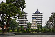
Daxian temple

"Water and fire"
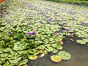
Loto pond in Baihe
.jpg)


Web links
Individual evidence
- ↑ 公所 介紹 (introduction). Baihe website, accessed December 23, 2018 .
- ↑ About Baihe> Local Overview History. Baihe website, accessed December 23, 2018 (Chinese).
- ↑ 各項 戶籍 人口統計 分析 表 (“Statistical analysis of demographic information on household registration”). Baihe Household Registration Authority, accessed December 22, 2018 (Chinese).
- ↑ 歷年 人口統計 ("Historical Demography"). Baihe Household Registration Authority, accessed December 22, 2018 (Chinese).
- ↑ 地方 沿革: 歷史 ("Local Development: History"). Baihe website, accessed December 22, 2018 (Chinese).
- ↑ 白河 區 里 行政 區域 圖 ("Baihe District Administrative Map"). Baihe website, accessed on December 22, 2018 (Chinese, size 46 MB!).
- ↑ a b Tainan City: Baihe District. Siraja National Landscaping Area, Taiwan Ministry of Tourism, accessed December 26, 2018 .
- ^ About Baihe> The Natural Glamor of Lotus in Four Seasons. Baihe website, accessed December 22, 2018 .
- ↑ 南寮 椪 柑 ("Nanliao-Ponkans"). Baihe website, accessed December 26, 2018 (Chinese).
- ^ Tourism and Travel. Baihe website, accessed December 26, 2018 .
- ↑ 風景 名勝 ("Viewpoints"). Baihe website, accessed December 26, 2018 (Chinese).
- ↑ Kanding Fu-an Temple (崁 頂 福安 宮). Tainan Tourist Office (twtainan.net), December 13, 2018, accessed on May 23, 2019 .
- ^ Tourism and Travel: Water and Fire Spring. Baihe website, accessed December 23, 2018 .
- ↑ 主題 之 旅: 水火 同源 ("Theme trip: water and fire"). Baihe website, accessed December 26, 2018 (Chinese).
- ↑ 溫泉 渡假 (“hot spring recreation area”). Baihe website, accessed December 26, 2018 (Chinese).
- ↑ 財團 法人 大仙 寺 ("Daxian Temple Foundation"). Temple website, accessed December 26, 2018 (Chinese).
Core city: center-west | Eastern District | South District | Northern District | Anping | Annan
Outer city: Anding | Baihe | Trimmings | Danei | Dongshan | Guanmiao | Guantian | Guiren | Houbi | Jiali | Jiangjun | Liujia | Liuying | Longqi | Madou | Nanhua | Nanxi | Qigu | Rende | Shanhua | Shanshang | Xiaying | Xigang | Xinhua | Xinshi | Xinying | Xuejia | Yanshui | Yongkang | Yujing | Zuozhen