
Xiaying (Tainan)
|
Xiaying 下 營 區 |
|||
.svg) Location of Xiaying in Tainan |
|||
| State : |
|
||
| Coordinates : | 23 ° 15 ' N , 120 ° 16' E | ||
| Area : | 33.5291 km² | ||
| Residents : | 23,838 (Feb 2019) | ||
| Population density : | 711 inhabitants per km² | ||
| Time zone : | UTC + 8 (Chungyuan time) | ||
| Telephone code : | (+886) (0) 6 | ||
| Postal code : | 735 | ||
| ISO 3166-2 : | TW-TNN | ||
| Community type : | Municipality of Tainan | ||
| Structure : | 15 districts ( 里 , Lǐ ) | ||
| Website : | |||
|
|||

Xiaying ( Chinese 下營區 , Tongyong Pinyin Siàyíng Cyu , W.-G. Hsia 4 -ying 2 Ch'ü 1 , PEH OE jī ¢-iâⁿ-khu ) is a district of the centrally-administered city of Tainan in the south west of the Republic of China on Taiwan .
Location and description
Xiaying is located in the northern section of the urban area of Tainan, about 25 to 30 kilometers north-northeast of the old, historic city center of Tainan. The district has approximately the shape of a triangle, the tip of which points to the northeast, with triangular edge lengths of 7 to 8 kilometers. With an area of about 33.5 km², Xiaying is the third smallest district outside of the core city of Tainan (ie in the area of the former Tainan district ). Xiaying is on the Jianan Plain and the terrain is correspondingly flat. The highest point is only about five meters above sea level. About two kilometers south of Xiaying the river Zengwen ( 曾文溪 , Céngwén Xī ) and a little north of Xiaying the small river Jishui ( 急水溪 , Jíshuǐ Xī ) flows to the west.
Xiaying is south of the Tropic of Capricorn and therefore in the tropics. The climate is characterized by the southwest monsoon , which brings about 90 percent of the annual precipitation in the summer months (especially June, July and August). The winters, on the other hand, are rather dry. The annual mean temperature is 23 to 24 ° C.
history
From the arrival of European colonial powers in Taiwan in the 17th century, the area was populated by members of the Siraya indigenous people . At that time the coastline was much further east and today's Xiaying had an indirect sea access via the later silted Neihaizi lagoon ( 內海 仔 ). The place name Xiaying (literally "lower (field) camp") comes from the time of the Kingdom of Tungning founded by Zheng Chenggong . At that time, Zheng tried to turn his domain into a base for regaining the Chinese mainland conquered by the Manchu , or to arm himself against attacks from the mainland. For this purpose, the area under his control was covered with a network of fortified farms or corresponding small settlements of Zheng's followers. The village name later became the name of the whole community. During the time of Japanese colonial rule (1895-1945), Xiaying became a 'village' ( 庄 , Zhuāng ) in Tainan Prefecture in 1920 . After the Republic of China took over Taiwan , the prefecture became Tainan County and the village became a rural community ( 鄉 , Xiāng ). With the annexation of the district to the city of Tainan on December 25, 2010, Xiaying received the status of a city district ( 區 , Qū ).
population
With fewer than 24,000 inhabitants (2019), Xiaying is one of the districts of Tainan with a smaller population. In 2017, 0.3 percent of the population belonged to the indigenous peoples .
| Structure of Xiaying |

|
administration

Before 2017, Xiaying was divided into 15 districts ( 里 , Lǐ ). In April 2017, the city administration ordered a reorganization in Xiaying as part of a major reorganization of all districts of Tainan. The 15 districts became 12 districts in two phases on January 29, 2018 and April 30, 2018.
1. Xiaying ( 下 營 里 )
2. Yingqian ( 營 前 里 )
3. Renli ( 仁里 里 )
4. Zhainei ( 宅內 里 )
5. Houjie ( 後街 里 )
6. Hongjia ( 紅 甲 里 )
7. Hejian ( 賀 建 里 )
8. Xinxing ( 新興 里 )
9. Maoying ( 茅 營 里 )
10. Kaihua ( 開化 里 )
11. Xilian ( 西 連 里 )
12. Daji ( 大吉 里 )
economy
Xiaying is characterized by agriculture. The alluvial plain shows productive soils. In 2017, 1974 hectares were used for agriculture. The most important products by acreage were rice, corn, sweet potatoes and citrus fruits . Cattle breeding (mostly pigs and geese) and aquaculture are also important.
traffic
In the west, the national road 1 (motorway) crosses the district in a north-south direction. Shortly before crossing the southern district border, it is crossed by the provincial expressway 84, which runs south-east. Provincial road 19A (19 甲 ) runs further to the east in a north-south direction. The district does not have a direct railway connection, but there are some in the neighboring eastern districts.
particularities
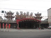
The Beji Dian Xuntian Temple ( 北極 殿 上帝 廟 , Běijí Diàn Shàngdì Miào , ) in the district of Xiaying is the largest temple in the district. Its beginnings go back more than 300 years. In the course of time numerous alterations, extensions and renovations took place. The first floor of the temple is Xuanwu dedicated to, the second floor of the Buddha and the third floor of the Jade Emperor Yu Di . Every year, special religious celebrations are held on the first five days of the lunar calendar . At the temple there is a small park in the Chinese style ( Wu Cheng'en Park 武承恩 公園 , Wǔ Chéng ēn Gōngyuán ). The Maogangwei Tianhou Temple ( 茅 港 尾 天 后宮 , Máogǎngwěi Tiānhòu Gōng , ), a Mazu temple in the district of Maoying, is similarly old.
![]()
![]()

Beji Dian Xuntian Temple
Maogangwei Tianhou Temple


Web links
Individual evidence
- ↑ 自然環境 ("Natural Environment"). Xiaying website, January 12, 2017, accessed May 5, 2019 (Chinese (traditional)).
- ↑ Introduction to various Village: Xiaying Village. Xiaying website, March 15, 2018, accessed May 5, 2019 .
- ↑ a b 地方 沿革 (“Development of the place”): 106 年下 營 區 統計 年報 (“Annual statistical report of the Xiaying district for the year 2017”). Xiaying website, January 14, 2019, accessed May 5, 2019 (Chinese (traditional)).
- ↑ 原住民 戶數 及 人數 Households and Persons of Indigenous People. (xls) Taiwan Ministry of the Interior, accessed May 5, 2018 (Chinese, English).
- ↑ 臺南市 里 鄰 編組 及 調整 情形 一覽表 ("List of Adjustments to Neighborhoods in Tainan City"). Retrieved March 23, 2019 (Chinese (traditional), borders before and after April 30, 2018 (pdf) ).
- ↑ 統計 年報 (“Annual Statistical Report”). Xiaying website, July 16, 2018, accessed May 5, 2019 (Chinese (traditional)).
- ↑ 下 營 北極 殿 玄天 上帝 廟 ("Beji-Dian-Xuntian Temple of Xiaying"). Temple website, accessed May 7, 2019 (Chinese (traditional)).
- ↑ 風景 名勝 ("Places of Interest"). Xiaying website, January 29, 2018, accessed May 7, 2019 .
- ↑ 茅 港 尾 天 后宮 ("Maogangwei Tianhou Temple"). Tainan Tourism Office (twtainan.net), December 13, 2018, accessed May 7, 2019 (Chinese (traditional)).
Core city: center-west | Eastern District | South District | Northern District | Anping | Annan
Outer city: Anding | Baihe | Trimmings | Danei | Dongshan | Guanmiao | Guantian | Guiren | Houbi | Jiali | Jiangjun | Liujia | Liuying | Longqi | Madou | Nanhua | Nanxi | Qigu | Rende | Shanhua | Shanshang | Xiaying | Xigang | Xinhua | Xinshi | Xinying | Xuejia | Yanshui | Yongkang | Yujing | Zuozhen