
Anding (Tainan)
|
Anding 安定 區 |
|||
.svg) Location of Anding in Tainan |
|||
| State : |
|
||
| Coordinates : | 23 ° 6 ' N , 120 ° 14' E | ||
| Height : | 3 - 5 m | ||
| Area : | 31.2700 km² | ||
| Residents : | 30,447 (Feb. 2019) | ||
| Population density : | 974 inhabitants per km² | ||
| Time zone : | UTC + 8 (Chungyuan time) | ||
| Telephone code : | (+886) (0) 6 | ||
| Postal code : | 745 | ||
| ISO 3166-2 : | TW-TNN | ||
| Community type : | Municipality of Tainan | ||
| Structure : | 13 districts ( 里 , Lǐ ) | ||
| Website : | |||
|
|||

Anding ( Chinese 安定 區 , Pinyin Āndìng Qū , W.-G. An1-ting4 Ch'ü1 , Pe̍h-ōe-jī An-tēng khu ) is a district of the government -direct city of Tainan in the southwest of the Republic of China on Taiwan .
Location and description
Anding is the historic "core city" of Tainan (in the borders before 2010) to the north, bordering on the Jianan plain . The height above sea level is only 3 to 5 meters above sea level, with no major variation. The district has a maximum longitudinal extent of about 9.3 kilometers in the northeast direction and a maximum transverse extent of about 5.4 kilometers in the southwest direction. With an area of 31.3 km², it is the second smallest district outside of the core city. The neighboring counties are Annan in the south, Xinshi and Shanhua in the east, Madou in the north, and Xigang in the northwest.
history
When Dutch colonizers arrived in Taiwan in the 17th century, Anding still had direct access to the sea via the later silted-up Taijiang lagoon . The area was then inhabited by members of the Siraya from the Tackalan tribe and referred to as Baccloan in the records of the Dutch company . Already during the Dutch rule, but especially at the time of the Kingdom of Tungning , founded by Zheng Chenggong , many Han Chinese settlers settled, mostly from the coastal provinces of Fujian and Guangdong , and soon formed the majority of the population. After a major flood in 1823, the river Zengwen ( 曾文溪 , Céngwén Xī ) changed its course, which meant that Anding lost its access to the sea (which is still reflected in many of today's place names) and became an inland community. During the phase of Japanese colonial rule (1895-1945), Anding became a 'village' ( 安定 庄 , Āndìng Zhuāng , Japanese. Antei Shō ) in 1920 and after Taiwan became part of the Republic of China , the village became the rural community of Anding ( 安定 鄉 , Āndìng Xiāng ) in the newly formed district of Tainan in 1946 . On December 25, 2010, the district was incorporated into the city of Tainan and Anding became a municipality ( 區 , Qū ).
population
The indigenous population makes up about 0.4 percent.
| Outline Andings |

|
Administrative division
An administrative reform took place on January 29, 2018 and April 30, 2018, in which the number of districts ( 里 , Lǐ ) was reduced from 16 to 13.
1 Sulin ( 蘇林 里 )
2 Sucuo ( 蘇 厝 里 )
3 Anding ( 安定 里 )
4 Anjia ( 安加里 )
5 Gangwei ( 港 尾 里 )
6 Wenke ( 文科 里 )
7 Hailiao ( 海 寮 里 )
8 Gangkou ( 港口里 )
9 Zhongrong ( 中 榮 里 )
10 Gangnan ( 港 南 里 )
11 Jiatong ( 嘉 同 里 )
12 Xinji ( 新 吉 里 )
13 Zhongsha ( 中 沙 里 )
traffic
In the north-eastern section, Anding is crossed by the national road 1 and in the western section by the provincial road 19 in north-south direction. In the south of Anding, the national road 8 runs in a west-east direction. The county road 178 runs through Anding approximately in a northeasterly direction.
economy
Local specialty agricultural products are sesame , asparagus and soap nuts .
Scientific institutions
In Anding there is part of the Tainan Science Park (the other parts are in the adjacent Xinshi and Shanhua districts) of the South Taiwan Science Park ( 南部 科學 工業 園區 , Nánbù Kēxué Gōngyè Yuánqū , Southern Taiwan Science Park ).
Special features and tourist destinations
Since 1864 there has been a festival every three years, in the third month of the lunar calendar , which is supposed to symbolically represent the expulsion of the plague from the town. At the festival, which has its origins in Chinese popular belief , a ship that resembles a scaled-down replica of an old Chinese warship is ritually burned in public. Similar ritual public ship cremations take place elsewhere in southern Taiwan.
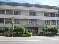
Anding District Office
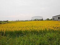
Sesame field in Anding


Web links
Individual evidence
- ↑ 自然環境 ("Natural Environment"). Anding website, February 14, 2019, accessed May 23, 2019 (Chinese (traditional)).
- ↑ JL Blussé, ME van Opstall, Ts'ao Yung-Ho (ed.): De dagregisters van het kasteel Zeelandia, Taiwan 1629-1662 (= Rijks Geschiedkundige Publicatiën . Volume 195, 229, 233, 241 ). Verlag Martinus Nijnhoff, s'Gravenhage 1986 (Dutch, digitized version with full-text search function at the Huygens Instituut voor Nederlandse Geschiedenis ).
- ^ Anding Township - What you must know. Archived from the original on February 21, 2014 ; accessed on May 23, 2019 (English).
- ↑ 歷史 沿革 ("Historical Development"). Anding website, February 14, 2019, accessed May 23, 2019 (Chinese (traditional)).
- ↑ 原住民 戶數 及 人數 Households and Persons of Indigenous People. (xls) Taiwan Ministry of the Interior, accessed May 5, 2018 (Chinese, English).
- ↑ 臺南市 里 鄰 編組 及 調整 情形 一覽表 ("List of Adjustments to Neighborhoods in Tainan City"). Retrieved May 23, 2019 (Chinese (traditional), borders before and after the 2018 adjustment ( pdf )).
- ^ Location of Townships. Anding website, May 1, 2018, accessed May 23, 2019 .
- ↑ 安定 三寶 ("Three Treasures Andings"). Anding's website, July 3, 2018, accessed May 23, 2019 (traditional Chinese).
- ^ Tainan Science Park. May 15, 2019, accessed on May 23, 2019 .
- ↑ King Boat Ceremony at Sucuo neighborhood, Anding District. Tainan Tourism Office (twtainan.net), 2018, accessed on May 23, 2019 .
- ↑ Sucuo First Daitian Temple (Temple Zhenhu) Wangye Boat Burning Festival, Anding. Ministry of Interior of the Republic of China (taiwangods.com), accessed May 23, 2019 .
Core city: center-west | Eastern District | South District | Northern District | Anping | Annan
Outer city: Anding | Baihe | Trimmings | Danei | Dongshan | Guanmiao | Guantian | Guiren | Houbi | Jiali | Jiangjun | Liujia | Liuying | Longqi | Madou | Nanhua | Nanxi | Qigu | Rende | Shanhua | Shanshang | Xiaying | Xigang | Xinhua | Xinshi | Xinying | Xuejia | Yanshui | Yongkang | Yujing | Zuozhen