
Guantian
|
Guantian 官田 區 |
|||
.svg) Location of Guantian in Tainan |
|||
| State : |
|
||
| Coordinates : | 23 ° 11 ' N , 120 ° 21' E | ||
| Area : | 70.7953 km² | ||
| Residents : | 21,279 (Feb. 2019) | ||
| Population density : | 301 inhabitants per km² | ||
| Time zone : | UTC + 8 (Chungyuan time) | ||
| Telephone code : | (+886) (0) 6 | ||
| Postal code : | 720 | ||
| ISO 3166-2 : | TW-TNN | ||
| Community type : | Municipality of Tainan | ||
| Structure : | 10 districts ( 里 , Lǐ ) | ||
| Website : | |||
|
|||

Guantian ( Chinese 官田 區 , Pinyin Guāntián Qū , W.-G. Kuan 1 -t'ian 2 Ch'ü 1 , Pe̍h-ōe-jī Koaⁿ-tiān-khu ) is a district of the government - direct city of Tainan in the southwest of the republic China on Taiwan .
Location and description
Guantian is located north-central in the urban area of Tainan. The district has an elongated shape with a maximum east-west extension of about 13.5 kilometers and a maximum north-south extension of about 7.5 kilometers. The western part of Guantian belongs to the more densely populated and intensively agricultural Jianan Plain , while the eastern part consists of forested hill country. The transition between the two zones is about 1 to 2 kilometers east of the motorway route of National Road 3 . In the east, larger parts of the Wushantou reservoir are located in the Guantian area. The southwest boundary to the neighboring Shanhua district is largely formed by the Zengwen River ( 曾文溪 , Céngwén Xī ). The other neighboring districts are Madou and Xiaying in the west, Liujia in the north, and Danei in the southeast and east.
history
The previous name was Guandian ( 官 佃 , Guāndiàn ). After the end of only a few decades spanning the Dutch colonial period in the 17th century Taiwan came under the control of Chinese authorities, first of of Zheng Chenggong justified Kingdom Tung Ning and 1683 the Qing - Empire . This was accompanied by a continuous immigration of Han Chinese from mainland China, who soon formed the majority of the population. After the Sino-Japanese War of 1894/95, Taiwan was annexed by Japan. In the early years of the subsequent 50 years of Japanese rule, there were frequent administrative reorganizations and Guantian experienced eight changes in its administrative structures during this time. In 1920 a permanent system of administration was set up and Guantian became a village ( 庄 , Zhuāng , Japanese Shō ) in Zengwen County, Tainan Prefecture . When Taiwan came to the Republic of China after World War II , Tainan Prefecture became Tainan County and Guantian became a rural community ( 鄉 , Xiāng ) of the county. On December 25, 2010, the district was dissolved, annexed to the city of Tainan and Guantian received the status of a city district ( 區 , Qū ).
population
With just over 21,000 inhabitants, Guantian was one of the smaller districts of Tainan in terms of population in 2019. Members of the Austronesian indigenous population only make up about 0.7 percent.
| Outline of Guantians |

|
Administrative division
Guantian is divided into 10 districts ( 里 , Lǐ ). Up to April 30, 2018 there were still 13 districts. At this time, three districts were each merged with the neighboring districts.
1 Nanbu ( 南 廍 里 )
2 Longben ( 隆 本 里 )
3 Dongxizhuang ( 東西 庄里 )
4 Longtian ( 隆 田里 )
5 Duba ( 渡 拔 里 )
6 Guantian ( 官 田里 )
7 Erzhen ( 二 鎮里 )
8 Wushantou ( 烏山 頭里 )
9 Daqi ( 大 崎 里 )
10 Shezi ( 社 子里 )
Transport links
.jpg)
.jpg)
National road 3 runs in a direct north-south direction through the middle of Guantian. It is crossed by Provincial Road 84, which runs along the southern district boundary, and then turns southeast. Provincial road 1 also runs essentially in north-south direction to the west of the motorway. There are also several district roads.
The longitudinal line of the Taiwanese Railway runs north-south through Guantian and has two stations here: Balin and Longtian. The route of the Taiwan High Speed Railroad (THSR) also runs through Guantian, but has no stop here.
Higher education and educational institutions
The National Art University of Tainan (TNNUA, 國立 臺南 藝術 大學 , Guólì Táinán Yìshù Dàxué ) is located in Guantian. The campus is located in the Daqi district near the Wushantou reservoir ( ). On March 19, 2018, the Center for Archaeological Research in Tainan ( 台南 考古 中心 , Táinán Kǎogǔ Zhōngxīn ) opened in Guantian.
![]()
economy
Guantian is strongly characterized by agriculture. A little more than 3000 hectares of land were used for agriculture in 2017. Rice cultivation dominated (~ 11,500 t on around 1750 ha). Quantitatively important were sugar cane (2300 t on 44 ha), watermelons (1100 t on 53 ha), pineapple (960 t on 20 ha), oranges and other citrus fruits (2750 t on 129 ha), mangoes (3530 t on 324 ha ), Bananas (400 t on 19 ha) and others (all figures for 2017). At the end of 2015 there were 194 businesses (mainly metal processing, food industry, textile industry, etc.).
Special features, sights
A visitor destination in Guantian is the Wushantou Reservoir and its surroundings. The associated dam was built in the 1920s according to plans by the Japanese hydraulic engineer Yoichi Hatta , and the lake is primarily used to supply water to agriculture. Appropriate leisure facilities can be found in the vicinity of the reservoir. At the reservoir, in the Daqi district, is the Wushantou Reservoir Temple of Heaven ( 烏 山頭 水庫 天壇 , Wūshāntóu Shuǐkù Tiāntán , ), a faithful replica of the Beijing Temple of Heaven on a scale of 1 to 6.
![]()
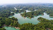
Wushantou Reservoir
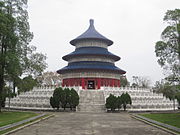
Wushantou Reservoir Temple of Heaven


people
- Chen Shui-bian , first President (2000–2008) of the Republic of China in Taiwan from the ranks of the DPP , was born in 1950 in Guantian
Web links
Individual evidence
- ↑ 區 里 簡介 ("Introduction to the District"). Guantian's website, January 15, 2019, accessed May 1, 2019 (Traditional Chinese).
- ↑ 原住民 戶數 及 人數 Households and Persons of Indigenous People. (xls) Taiwan Ministry of the Interior, accessed May 5, 2018 (Chinese, English).
- ↑ 臺南市 里 鄰 編組 及 調整 情形 一覽表 ("List of Adjustments to Neighborhoods in Tainan City"). Retrieved May 1, 2019 (Chinese (traditional), map before and after the 2018 area adjustments ).
- ↑ 國立 臺南 藝術 大學 Tainan National University of the Arts. University website, accessed on May 1, 2019 (English, Chinese (traditional)).
- ↑ Duncan DeAeth: Center for Archeology Research opens in southern Taiwan. Taiwan News, March 19, 2018, accessed May 5, 2019 .
- ↑ 統計 資訊 ("Statistical Information"). Guantian's website, July 30, 2018, accessed May 1, 2019 (traditional Chinese).
- ↑ 烏 山頭 水庫 (Wushantou Reservoir). Guantian's website, November 3, 2015, accessed May 1, 2019 (traditional Chinese).
Core city: center-west | Eastern District | South District | Northern District | Anping | Annan
Outer city: Anding | Baihe | Trimmings | Danei | Dongshan | Guanmiao | Guantian | Guiren | Houbi | Jiali | Jiangjun | Liujia | Liuying | Longqi | Madou | Nanhua | Nanxi | Qigu | Rende | Shanhua | Shanshang | Xiaying | Xigang | Xinhua | Xinshi | Xinying | Xuejia | Yanshui | Yongkang | Yujing | Zuozhen