
Xinhua (Tainan)
|
Xinhua 新化 區 |
|||
.svg) Location of Xinhua in Tainan |
|||
| State : |
|
||
| Coordinates : | 23 ° 2 ' N , 120 ° 19' E | ||
| Area : | 62.0579 km² | ||
| Residents : | 43,418 (Feb 2019) | ||
| Population density : | 700 inhabitants per km² | ||
| Time zone : | UTC + 8 (Chungyuan time) | ||
| Telephone code : | (+886) (0) 6 | ||
| Postal code : | 712 | ||
| ISO 3166-2 : | TW-TNN | ||
| Community type : | Municipality of Tainan | ||
| Structure : | 16 districts ( 里 , Lǐ ) | ||
| Website : | |||
|
|||

Xinhua ( Chinese 新化 區 , Tongyong Pinyin Sinhuà Cyu , W.-G. Hsin 1 -hua 4 Ch'ü 1 ) or Sinhua is a district of the government- direct city of Tainan in the southwest of the Republic of China on Taiwan .
Location and description
Xinhua is located in the southern metropolitan area of Tainan, about 15 to 20 kilometers west of the historic city center of Tainan. The district is located in the transition zone between the Jianan Plain to the west and the hill country further east. The approximate limit is the national road 3 (motorway). The neighboring districts are Xinshi and Shanshang in the north, Zuozhen in the east, Longqi and Guanmiao in the south, and Yongkang in the west.
history
Until the 17th century, members of Austronesian ethnic groups lived in the area of Xinhua, most recently members of the Siraya . In the Dagregisters van het kasteel Zeelandia of the Dutch East India Company , the place is documented under the name Tavocan (or in slightly varying spelling) (in Chinese transcription: 大 目 降 or 大 穆 降 , Dàmù Jiàng ). The company exercised only a relatively loose rule and left the villages largely self-governing. Once a year a village representatives meeting was called to Fort Provintia . After Zheng Chenggong and his followers took over the area in 1661, the administration tightened significantly. Tavocan was subordinated to Tianxing County ( 天 興縣 ). After Taiwan's incorporation into the Qing Empire in 1683, Tavocan was organized as a village ( 庄 , Zhuāng ) in Taiwan County ( 台灣 縣 , Táiwān Xiàn ) in Taiwan Prefecture ( 台灣 府 , Táiwān Fǔ ). From the 17th century onwards, Han Chinese immigrants began to flow increasingly from mainland China to Taiwan, where over time they formed the majority of the population. In the 19th century, Tavocan was one of the largest settlements in southern Taiwan.
During the time of the Japanese rule (1895-1945), various larger administrative reorganizations followed, most recently in 1920 when Xinhua became a 'street' ( 街 , Japanese. Machi , Chinese. Jiē ) in the district of the same name ( 県 , Ken ) Xinhua. After Taiwan's handover to the Republic of China , it became the municipality of Xinhua ( 新化 鎮 , Xīnhuà Zhèn ) in the newly established Tainan County . With the dissolution of the district and the annexation to the city of Tainan on December 25, 2010, Xinhua received the status of a city district ( 區 , Qū ).
Xinhua was severely affected by the Kaohsiung earthquake on February 6, 2016 .
population

With a population of around 43,000, the district was one of Tainan's mid-range counties in 2019. Members of indigenous peoples form only a small minority of around 0.3%.
| Structure of Xinhuas |

|
Administrative division
Before January 29, 2018, Xinhua was divided into 20 districts ( 里 , Lǐ ). On January 29, 2018, there was a reorganization and division into 16 districts.
1 Beishi ( 北 勢 里 )
2 Fengkou ( 唪 口里 )
3 Xiexing ( 協 興 里 )
4 Fengrong ( 豐 榮 里 )
5 Wu'an ( 武 安 里 )
6 Quanxing ( 全興 里 )
7 Lunding ( 崙 頂 里 )
8 Shanjiao ( 山脚 里 )
9 Zhiyi ( 知 義 里 )
10 Dakeng ( 大 坑里 )
11 Jiaokeng ( 礁 坑里 )
12 Yanglin ( 羊 林 里 )
13 Naba ( [那] 拔 里 )
14 Huguo ( 護 國 里 )
15 Dongrong ( 東 榮 里 )
16 Taiping ( 太平 里 )
traffic
The main road connections are the national road 3 (motorway), which crosses the district in a north-south direction, as well as the provincial roads 19A (19 甲 , also north-south direction), 20 (north-west direction) and 39 (short section in the west) . There is no direct railway connection. In the west, the Taiwan High Speed Railroad (THSR) crosses the district without stopping.
economy
Agriculture continues to play an important role in Xinhua. The most important crops are rice , sweet potatoes , sugar cane , bamboo shoots , watermelon , pineapple , mango , banana , and lychee . Pig breeding is predominantly carried out on farm animals. In 2016, there were 89 commercial enterprises in Xinhua. The largest share (21) was made up of food processing companies.
Special features and tourist destinations
The urban center of Xinhua with the "old street" ( 新化 老街 , Xīnhuà Lǎo Jiē , ) is worth seeing. The Wude Temple ( 武德 殿 , Wǔdé Diàn , ) on the 'Old Street' was built during the Japanese rule between 1925 and 1928 and originally served as a judo and kendō training hall. Also on the 'Old Street' is the Chaotian Temple ( 朝天宮 , Cháotiān Gōng , ) of Xinhua, a Mazu temple that dates back to 1807. In the Hutoupi landscape area ( 虎頭 埤 „ , Hǔtóupí Fēngjǐng Qū ) in the Jiaokeng district there is the small reservoir of the same name ( 虎頭 埤 -" Tiger's Head Lake "), which was created in 1846. It originally served as a water supply for agriculture and is now also a tourist destination. The Siraya National Landscape Area ( 西拉雅 國家 風景區 ), which extends east of National Road 3, has many natural attractions, including the 90-hectare forest station Xinhua ( 新化 林場 , Xīnhuà Línchǎng ) of the Chung-Hsing- National University (NCHU).
![]()
![]()
![]()
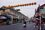
'Old Street' in Xinhua

Chaotian Temple

Hutoupi
.jpg)

.jpg)
Web links
Individual evidence
- ↑ JL Blussé, ME van Opstall, Ts'ao Yung-Ho (ed.): De dagregisters van het kasteel Zeelandia, Taiwan 1629-1662 (= Rijks Geschiedkundige Publicatiën . Volume 195, 229, 233, 241 ). Verlag Martinus Nijnhoff, s'Gravenhage 1986 (Dutch, digitized version with full-text search function at the Huygens Instituut voor Nederlandse Geschiedenis ).
- ↑ a b c d 行政 沿革 ("Administrative Development"). Xinhua website, April 13, 2018, accessed April 27, 2019 (Traditional Chinese).
- ↑ 原住民 戶數 及 人數 Households and Persons of Indigenous People. (xls) Taiwan Ministry of the Interior, accessed May 5, 2018 (Chinese, English).
- ↑ 臺南市 里 鄰 編組 及 調整 情形 一覽表 ("List of Adjustments to Neighborhoods in Tainan City"). Retrieved April 4, 2019 (Chinese (traditional), borders before and after January 29, 2018 ( pdf )).
- ↑ 106 年 臺南市 新化 區 統計 年報 (“Annual Statistical Report of the Xinhua District of Tainan in 106 according to the Monguo Calendar”). Xinhua District website, July 31, 2018, accessed April 27, 2019 (Traditional Chinese, English).
- ↑ Xinhua Old Street (新化 老街). December 13, 2018, accessed April 27, 2019 .
- ↑ Xinhua Wude Temple (新化 武德 殿). www.twtainan.net, accessed on April 27, 2019 (English).
- ↑ Xinhua Chaotian Temple (新化 朝天宮). www.twtainan.net, December 13, 2018, accessed on April 27, 2019 (English).
- ↑ 虎頭 埤 風景區 ("Hutoupi Landscape Area"). htp.tainan.gov.tw, accessed April 27, 2019 (Chinese (traditional), English).
- ↑ SINHUA Forest Area. Siraya National Landscape Area (www.siraya-nsa.gov.tw), accessed on April 25, 2019 .
- ↑ Xinhua Forest Station (國立 中興 大學 新化 林場). www.twtainan.net, December 13, 2018, accessed on April 27, 2019 (English).
Core city: center-west | Eastern District | South District | Northern District | Anping | Annan
Outer city: Anding | Baihe | Trimmings | Danei | Dongshan | Guanmiao | Guantian | Guiren | Houbi | Jiali | Jiangjun | Liujia | Liuying | Longqi | Madou | Nanhua | Nanxi | Qigu | Rende | Shanhua | Shanshang | Xiaying | Xigang | Xinhua | Xinshi | Xinying | Xuejia | Yanshui | Yongkang | Yujing | Zuozhen