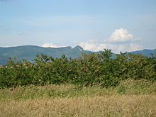
Kozara
Kozara ( Serbian - Cyrillic Козара ) is a low mountain range in the north-western part of Bosnia and Herzegovina . It is located in the Bosanska Krajina between the Sava , Una , Sana and Vrbas rivers and begins around 30 kilometers northwest of Banja Luka . Most of the mountain belongs to the Prijedor municipality in the Republika Srpska . The Hercynian- oriented mountains are around 40 kilometers long and 10 kilometers wide. The highest point is Mount Lisina at 978 meters above sea level. The Kozara Mountains merge into the smaller Prosara Mountains in the north and the Piskavica Mountains in the south .
The Kozara massif has a very dynamic relief. The Mrakovica plateau (806 m) occupies the central part of the mountain range . Other important peaks are: Gola planina (876 m), Rudine (750 m), Jarčevica (740 m), Glavuša (793 m), the Bešić plateau (784 m), Vrnovačka glava (719 m), Benkovac-Jurišina kosa (705 m), Šupljikovac (652 m), Zečiji came (667 m) and Kozarački came (659 m).
A large part of the Kozara Mountains is taken by the Kozara National Park , which was inaugurated in 1967 to protect the cultural and historical values of the area. It has an area of 3520 hectares . The national park is a member of the Association of National Parks of Europe .
On the top of the Mrakovica plateau, the monument to the revolution by the sculptor Dušan Džamonja , commemorating the Kozara battle during World War II , was inaugurated in 1972 . In the battle, German , Croatian and Hungarian units met Yugoslav partisans as part of Operation West Bosnia .
Individual evidence
- ↑ Association of the National Parks of Europe ( Memento of the original from January 17, 2009 in the Internet Archive ) Info: The archive link has been inserted automatically and has not yet been checked. Please check the original and archive link according to the instructions and then remove this notice.
Web links
- Homepage of the Kozara National Park (English and Serbian)
Coordinates: 44 ° 58 ' N , 16 ° 55' E

