Kapuvár district
| circle Kapuvári járás
Kapuvár |
|
|---|---|
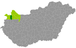
 Location of the Kapuvár district (green) with the remaining districts in Győr-Moson-Sopron County (light green) in Hungary. |
|
| Basic data | |
| Country | Hungary |
| County | Győr-Moson-Sopron |
| Seat | Kapuvár |
| surface | 392 km² |
| Residents | 24,440 (January 1, 2016) |
| density | 62 inhabitants per km² |
The district of Kapuvár (Hungarian Kapuvári járás ) is a district in the center of the northwestern Hungarian county Győr-Moson-Sopron . It borders on Sopron County in the west, Csorna County in the east and Vas County in the south. In the north, the town of Kapuvár forms the border with Austria ( Burgenland ).
history
The district was created during the administrative reform in early 2013 from the forerunner, the small area Kapuvár-Beled (Hungarian Kapúvar-Beledi kistérség ), additionally reinforced by the southwestern municipality of Répceszemere from the small area Sopron-Fertőd . Between 2007 and 2014, the municipality of Agyagosszergény was part of the Sopron-Fertőd small area or the Sopron district .
Community overview
The Kapuvár District has an average municipality size of 1,222 inhabitants on an area of 19.60 square kilometers. The population density of the small district is below that of the county. The administrative seat is the largest city Kapuvár , located in the center of the district.
| local community | status | Origin small area |
population | Area (km²) | Population density (inh / km²) |
||
|---|---|---|---|---|---|---|---|
| October 01, 2011 | 01/01/2013 | 01/01/2016 | |||||
| Agyagosszergény | local community | Sopron-Fertőd | 900 | 908 | 937 | 19.89 | 47.1 |
| Babot | local community | Kapuvár-Beled | 1,118 | 1,125 | 1,120 | 21.67 | 51.7 |
| Beled | city | Kapuvár-Beled | 2,633 | 2,656 | 2,632 | 26.47 | 99.4 |
| Cirák | local community | Kapuvár-Beled | 587 | 575 | 569 | 11.76 | 48.4 |
| Dénesfa | local community | Kapuvár-Beled | 453 | 355 | 340 | 17.54 | 19.4 |
| Edve | local community | Kapuvár-Beled | 114 | 119 | 123 | 5.05 | 24.4 |
| Gyóró | local community | Kapuvár-Beled | 379 | 382 | 388 | 11.64 | 33.3 |
| Himod | local community | Kapuvár-Beled | 616 | 635 | 605 | 22.70 | 26.7 |
| Hövej | local community | Kapuvár-Beled | 288 | 308 | 298 | 8.52 | 35.0 |
| Kapuvár | city | Kapuvár-Beled | 10,495 | 10,498 | 10,431 | 96.05 | 108.6 |
| Kisfalud | local community | Kapuvár-Beled | 748 | 760 | 746 | 15.10 | 49.4 |
| Mihályi | local community | Kapuvár-Beled | 1,079 | 1,063 | 1,025 | 16.28 | 68.6 |
| Osli | local community | Kapuvár-Beled | 900 | 907 | 861 | 18.80 | 45.8 |
| Rábakecöl | local community | Kapuvár-Beled | 684 | 683 | 651 | 23.03 | 28.3 |
| Répceszemere | local community | Sopron-Fertőd | 284 | 296 | 314 | 9.42 | 33.3 |
| Szárföld | local community | Kapuvár-Beled | 899 | 883 | 916 | 17.11 | 53.5 |
| Vadosfa | local community | Kapuvár-Beled | 75 | 68 | 83 | 4.19 | 19.8 |
| Vásárosfalu | local community | Kapuvár-Beled | 155 | 163 | 148 | 4.20 | 35.2 |
| Veszkény | local community | Kapuvár-Beled | 944 | 923 | 941 | 10.35 | 90.9 |
| Vitnyéd | local community | Kapuvár-Beled | 1,327 | 1.306 | 1.312 | 32.25 | 40.7 |
| Kapuvár district | 24,678 | 24,613 | 24,440 | 392.02 | 62.3 | ||
swell
PDF and XLS files: 2011
Census :
2013:; 2016:
Individual evidence
- ↑ KSH: 2011. Évi Népszámlálás. In: 3. Területi adatok. KSH, accessed on December 26, 2016 (Hungarian, also via: http://www.terezvaros.hu/testuleti/nepsz2011-3/pdf/nepsz2011_03_08.pdf ).
- ↑ KSH: Regional data - Győr-Moson-Sopron county. KSH, accessed on December 26, 2016 (English, 4th Data on Localities).
- ↑ KSH: Gazetteer of Hungary, 1st January, 2013. KSH, accessed on March 23, 2017 (Hungarian / English).
- ↑ KSH: Gazetteer of Hungary, 1st January, 2016. KSH, accessed on March 23, 2017 (Hungarian / English).