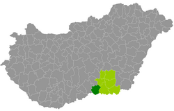
Mórahalom County
| circle Mórahalmi járás
Mórahalom |
|
|---|---|
 Location of the district in Hungary |
|
| Basic data | |
| Country | Hungary |
| County | Csongrád-Csanád |
| Seat | Mórahalom |
| surface | 561.7 km² |
| Residents | 28,656 (January 1, 2016) |
| density | 51 inhabitants per km² |
Mórahalom (Hungarian Mórahalmi járás ) is a district in the southwest of the southern Hungarian county of Csongrád-Csanád . It borders Bács-Kiskun County to the north and west and Serbia (2 border municipalities) to the south .
history
During the Hungarian administrative reform in early 2013, the district emerged as the successor to the disbanded small area of the same name ( Mórahalomi kistérség ) with 9 municipalities. In addition, the district received a municipality from the small area of Szeged , which was also dissolved at the end of 2012 .
Community overview
Mórahalom County has an average parish size of 2,866 inhabitants in an area of 56.17 square kilometers. The population density of the third poorest district is below that of the county. The administrative center is the largest city, Mórahalom , in the southeast of the district.
| local community | status | Origin small area |
population | surface | Population density (inh / km²) |
||
|---|---|---|---|---|---|---|---|
| October 01, 2011 | 01/01/2013 | 01/01/2016 | |||||
| Ásotthalom * | Large community | Mórahalom | 4.122 | 3,841 | 3,895 | 122.54 | 31.8 |
| Bordany | Large community | Mórahalom | 3,230 | 3,258 | 3,283 | 36.48 | 90.0 |
| Forráskút | local community | Mórahalom | 2,287 | 2,315 | 2,252 | 36.67 | 61.4 |
| Mórahalom * | city | Mórahalom | 5,804 | 5,822 | 6,017 | 83.14 | 72.4 |
| Öttömös | local community | Mórahalom | 699 | 710 | 705 | 30.91 | 22.8 |
| Pusztamérges | local community | Mórahalom | 1,212 | 1,187 | 1,073 | 24.39 | 44.0 |
| Ruzsa | local community | Mórahalom | 2,480 | 2,485 | 2,440 | 84.68 | 28.8 |
| Üllés | Large community | Mórahalom | 3,046 | 3,062 | 2,960 | 49.93 | 59.3 |
| Zákányszék | local community | Mórahalom | 2,744 | 2,697 | 2,730 | 66.07 | 41.3 |
| Zsombó | Large community | Szeged | 3,362 | 3,364 | 3,301 | 26.89 | 122.8 |
| Mórahalom County | 28,986 | 28,741 | 28,656 | 561.70 | 51.0 | ||
* Border municipality to Serbia
swell
PDF and XLS files: 2011
Census :
2013:; 2016:
Individual evidence
- ↑ KSH: 2011. Évi Népszámlálás. In: 3. Területi adatok. KSH, accessed on December 24, 2016 (Hungarian, also via: http://www.terezvaros.hu/testuleti/nepsz2011-3/pdf/nepsz2011_03_06.pdf ).
- ↑ KSH: Regional data - Csongrád county. KSH, accessed on December 24, 2016 (English, 4th Data on Localities).
- ↑ KSH: Gazetteer of Hungary, 1st January, 2013. KSH, accessed on March 19, 2017 (Hungarian / English).
- ↑ KSH: Gazetteer of Hungary, 1st January, 2016. KSH, accessed on March 19, 2017 (Hungarian / English).