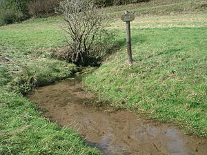
Kressenborn (Bornaibach)
| Kressenborn | |
|---|---|
 Karst spring Kressenborn |
|
| location | |
| Country or region | near Frankershausen ; Werra-Meißner-Kreis , Hessen ( Germany ) |
| Coordinates | 51 ° 14 ′ 53 " N , 9 ° 54 ′ 54" E |
| geology | |
| Mountains | High Meissner |
| Source type | Karst spring |
| rock | dolomite |
| Hydrology | |
| River system | Weser |
| Receiving waters | Bornaibach → Berka → Werra → Weser → North Sea |
Coordinates: 51 ° 14 ′ 53 ″ N , 9 ° 54 ′ 54 ″ E
The Kressenborn is a karst spring designated as a natural monument near Frankershausen in the Werra-Meißner district of Hesse . Like the neighboring Breitenborn, it feeds the Berka tributary Bornaibach .
description
The Kressenborn is located in the Geo-Naturpark Frau-Holle-Land (Werratal.Meißner.Kaufunger Wald) north of the Berkatal district of Frankershausen between the two sections of the Kripp- and Hielöcher nature reserve , about 100 m west of the Breitenborn. The outflow of both sources forms the Bornaibach , which already operates the Oberdorfer Mühle after about 200 m and the Blaumühle 500 m further downstream and flows into the Berka in Frankershausen. The spring water of the Kressenborn springs from under an elder bush , then flows into a dammed up small depression and crosses under a dirt road.
In the 15th century, the town of Borne , whose name goes back to the springs, was located near the two karst springs.
See also
Web links
- Breitenborn and Kressenborn , on home.arcor.de
Individual evidence
- ↑ Borne, Werra-Meißner district. Historical local dictionary for Hessen. (As of July 25, 2012). In: Landesgeschichtliches Informationssystem Hessen (LAGIS).

