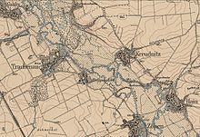
Kreudnitz
Kreudnitz was a village south of Leipzig that fell victim to lignite mining between 1968 and 1971 as a result of the Witznitz II opencast mine . In 1971, the corridor of the devastated place was incorporated into Rötha in the Leipzig district (Free State of Saxony ).
location
Kreudnitz was between Rötha in the north-west and Borna in the south-east in the southern part of the Leipzig lowland bay . The former post road from Leipzig to Altenburg ran through the village, following the route of the medieval trade route Via Imperii . With the construction of the higher-lying trunk road via Espenhain at the beginning of the 19th century, Kreudnitz lost this connection.
Kreudnitz was on the northeastern edge of the Pleißenaue , which is why its field corridor extended to the northeast and meadow terrain was to be found in the southeast.
The surrounding places were from the north in a clockwise direction Rötha, Espenhain, Hain , Kahnsdorf , Trachenau with Treppendorf and Gaulis .
The Rötha reservoir was built northwest of Kreudnitz in 1942 , the southern part of which, like Kreudnitz, disappeared due to the lignite mining. The location of Kreudnitz at that time corresponds roughly to the north-eastern edge of the Kahnsdorfer See or the north-south dam, which was built around 1980 and separates the Kahnsdorf and Hainer lakes .
history
The map of Kreudnitz shows that it was created from two round pieces . The village was first mentioned in 1417 as Krudenicz. The manorial rule initially lay with the Kitzscher manor , but in 1654 it was transferred to Rötha.
The small village church, whose construction time nothing was known, had a mighty roof turret . It has been looked after by a pastor together with that of the neighboring village of Hain since 1543. Both churches were regarded as sister churches with equal rights.
Until 1856, Kreudnitz was in the Electoral Saxon or Royal Saxon Office of Borna . From 1856 Kreudnitz belonged to the Rötha court office and from 1875 to the Borna district administration . On September 1, 1948, Kreudnitz was incorporated into Hain.
For a long time Kreudnitz remained untouched by lignite mining in the Borna district. This changed after construction site 2 was opened in the south-western Witznitz II opencast mine in 1960 with the construction of the Kahnsdorf pivot point. In 1963/64, in preparation for coal mining, the Pleiße was led around the opencast mine in the west.
- Impressions from Kreudnitz
Two bells of the Kreudnitz church were transferred in 1967 to the newly built little church of Stein in the Chemnitz valley in the then Rochlitz district . In 1968 Kreudnitz was dissolved and its corridor was excavated in 1969. At the time of the resettlement, Kreudnitz had 175 inhabitants. In 1971 the Rötha corridor area was added.
The change in economic policy that came with German reunification in 1989/90 led to a drastic decline in the demand for lignite, which meant that the Witznitz II open-cast mine was shut down early by 1993 despite the presence of deposits. From the renatured remaining hole the Hainer and the Kahnsdorfer See were created, to whose area the former location Kreudnitz belongs.
Web links
- Kreudnitz in the Digital Historical Directory of Saxony
Individual evidence
- ↑ Saxony's Church Gallery. The inspections: Borna and Pegau. Dresden 1841
- ↑ New Saxon Church Gallery. The ephorie Borna. Leipzig 1903
- ^ Karlheinz Blaschke , Uwe Ulrich Jäschke : Kursächsischer Ämteratlas. Leipzig 2009, ISBN 978-3-937386-14-0 ; P. 62 f.
- ^ The Borna District Administration in the municipal directory 1900
- ↑ Kreudnitz on gov.genealogy.net
- ↑ List of cultural monuments in the Königshain-Wiederau community, Stein section
Coordinates: 51 ° 10 ′ 53 ″ N , 12 ° 26 ′ 0 ″ E


